Trading gold for salt
Mali | Anno 1998
Timbuktu. Few places in the world capture the imagination as much as this oasis on the southern edge of the Sahara. It was once an important hub for trans-Saharan trade. Huge caravans carrying their precious cargoes crossed the vast desert, making the city one of the richest in West Africa. The Niger supplied enough fresh water, so that agriculture and livestock kept the city viable. The peak came in the 15th and 16th centuries, the Golden Age of Timbuktu, when the oasis became a centre of art and culture, of philosophy and literature, of luxury and wealth.
Huge caravans carrying their precious cargoes crossed the vast desert, making the city one of the richest in West Africa
Today, the city has faded into the mists of history. The population has declined significantly and what remains of the oasis is largely shrouded in mystery. Its remote location in an inhospitable environment also gives the city a halo of inaccessibility. Completely wrong of course, because nowadays you can go there even by plane. But we opt for a more lifelike approach – a boat trip on the Niger. Along the way we hope to get to know the people that manage to survive in this demanding environment.
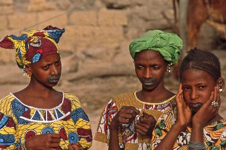
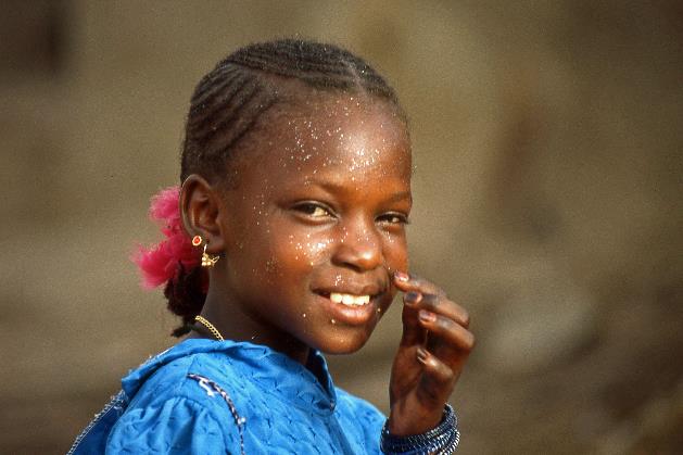
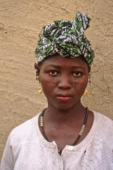
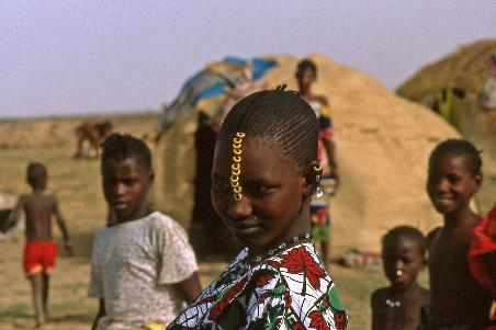
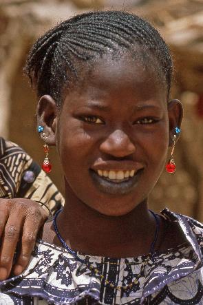
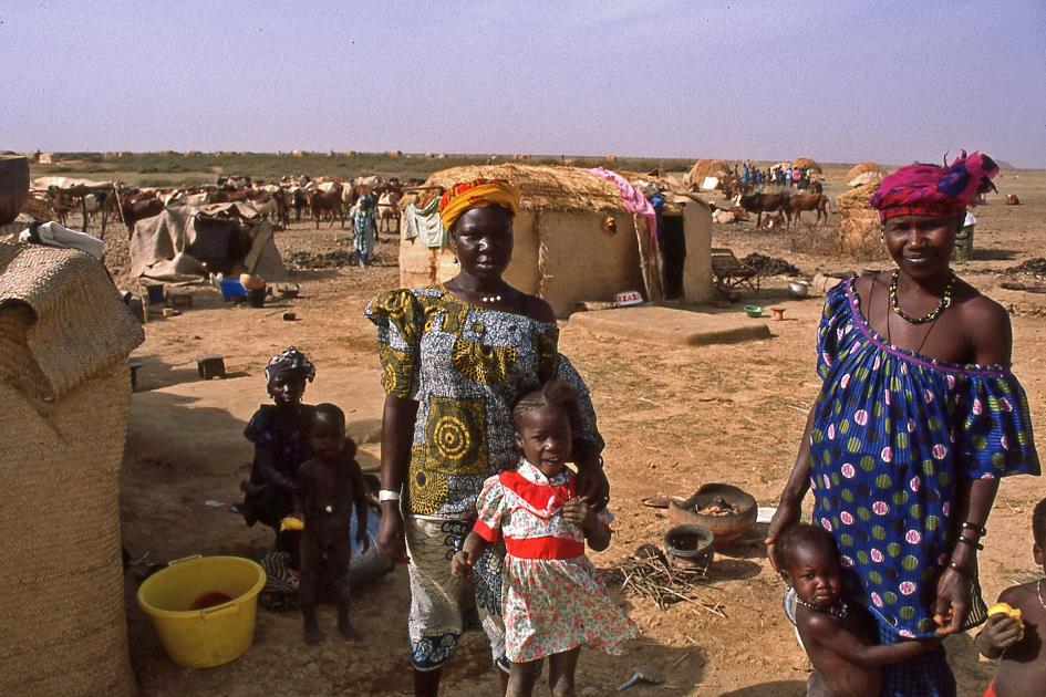
Even with our untrained eye, we can get the Fula women out in no time
Fula women |
|
|
|
|
|
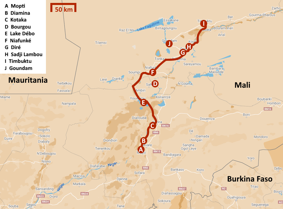
We have set aside three days for this. After two days of sailing, we will arrive in Timbuktu in the morning on the third day, with plenty of time to explore the city. And sure enough, we return to the capital Bamako by plane.
They sometimes call Mopti the Venice of Mali. To agree to that, you have to put on some rose-coloured glasses
But we're not that far yet. For the time being we are still in Mopti, a lively port city with over forty thousand inhabitants at the confluence of the Niger and the Bani. They sometimes call this city the Venice of Mali. To agree to that, you have to put on some rose-coloured glasses. For more than half of the year, the fields are bone dry and the sand swirls through the dusty streets, with no water in sight.
But that will change in August. The water level of the rivers then rises noticeably and reduces the city to a few inhabited islands completely surrounded by water. If you want to reach the city from the interior, you can only do so via the twelve kilometres long, straight dike road from Sévaré. That situation lasts until December, when the water recedes and gives up the fertile rice fields around the city.
|
|
|
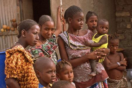
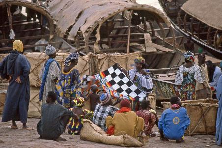
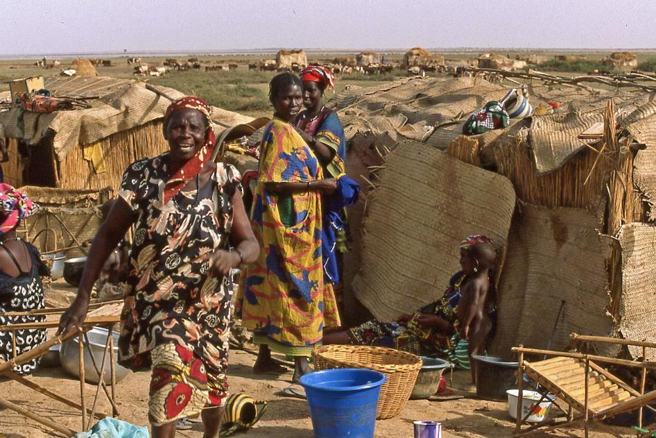
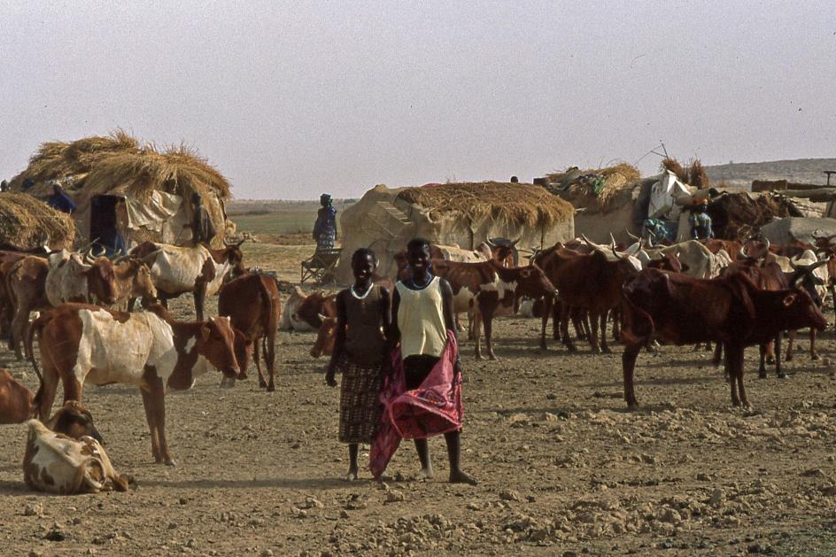
As befits a port city, Mopti has a cosmopolitan character. You can guess that from its name. Loosely translated, it means Where the tribes meet, Dramane explains, leading us to the old quarter of the city. A dozen different tribes live here – Fula, Bozo, Tuareg, Songhai, Bambara, Dogon, … just to name the most important. Yet Mopti is primarily a city of the Fula.
|
|
|
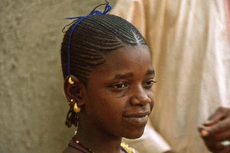
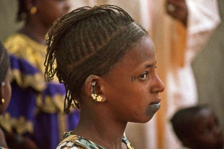
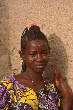
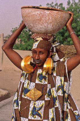
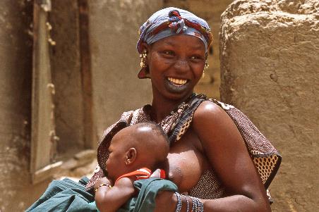
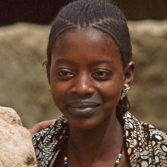
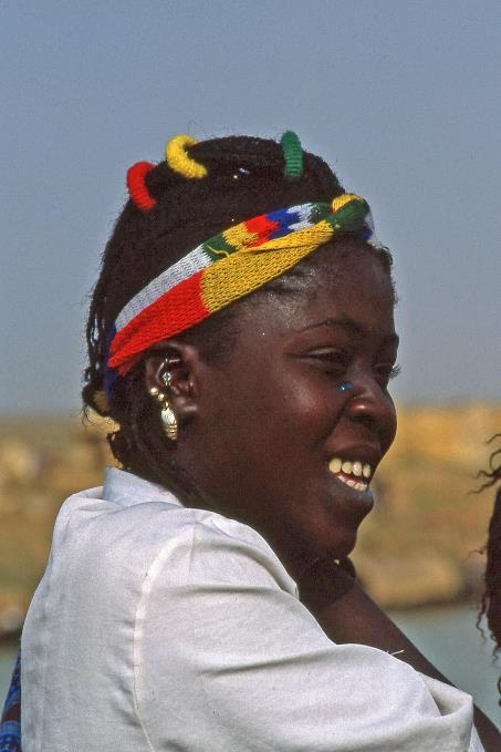
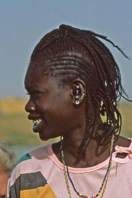
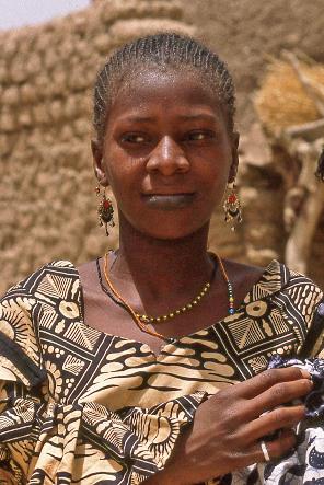
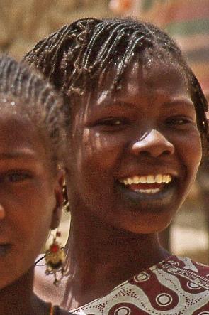
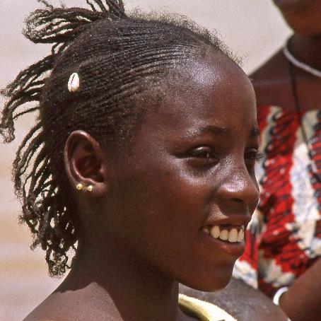
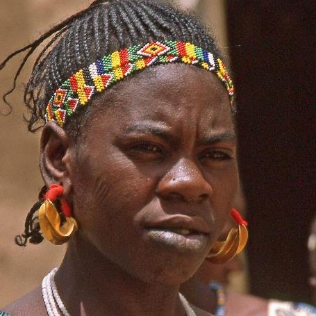
Recognizing the facial features of all those peoples is, of course, too ambitious for us. Except when it comes to the Fula, or the Peul as they were called by the French colonizer. Even with our untrained eye, we can get the Fula women out in no time. This is partly due to their skin colour – brown rather than black – but mainly due to the prominent facial tattoos and the elongated, oval shape of their graceful faces. In particular, the black spots around the lips and mouth are very noticeable. A mild form of facial mutilation is also used. This happens at a very young age, in both girls and boys. The small incisions, especially under the eyes, usually refer to the ethnic origin of the girls. In some cases, they are a sign that the girl is already reserved for a particular man.
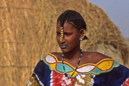
Fula woman with jewellery |
|
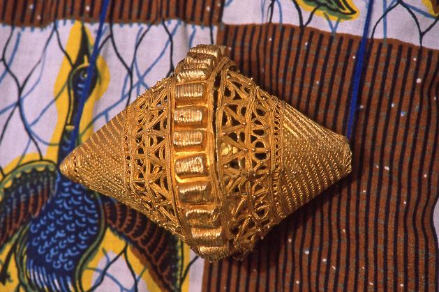
Double cone of filigree gold |
Yet it is mainly their jewellery with which the Fula women impress us. Of course they don't wear it day in day out. But Dramane succeeds in convincing a woman to show her precious family heirlooms. The result is astonishing. On her chest she wears a beautiful ornament in the shape of a double cone of filigree gold. But it's the unique earrings, the kwottone kanye, that draw all the attention. It is not without reason that they are among the most talked-about pieces of jewellery that you can find in Africa. Even international jewellers like to have such showpieces in their offer. The banana-shaped double shells in gold leaf are fifteen centimetres long. They dangle with a thick red rope from the earlobes that have stretched quite a bit over the years, so that the jewels hang well over the shoulders.
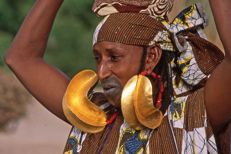
It is not without reason that kwottone kanye are among the most talked-about pieces of jewellery that you can find in Africa. Even international jewellers like to have such showpieces in their offer
Such jewels are passed on from mother to eldest daughter or acquired through a dowry. The larger the earrings, the heavier they are and the more the woman's earlobes are stretched. The latter in particular is seen as a sign of wealth. Dramane estimates the value of this jewellery at three million CFA1). In this country that is a huge fortune. Yet this woman just keeps her valuables at home. We wonder whether that is safe. Dramane laughs our fears away. At the mere sight of these valuables, any would-be thief would immediately freeze and dare not take anything, he claims.
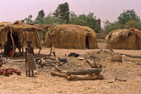
The Fula originally are nomadic herders. Quite logical that they invest in jewellery, so that they can easily take their assets with them wherever they go. Many Fula have now turned their backs on nomadic life. Nevertheless, there are still some nomadic Fula in the city. This can be deduced from the presence of houses made of rice straw, a typical form of temporary housing, Dramane says.
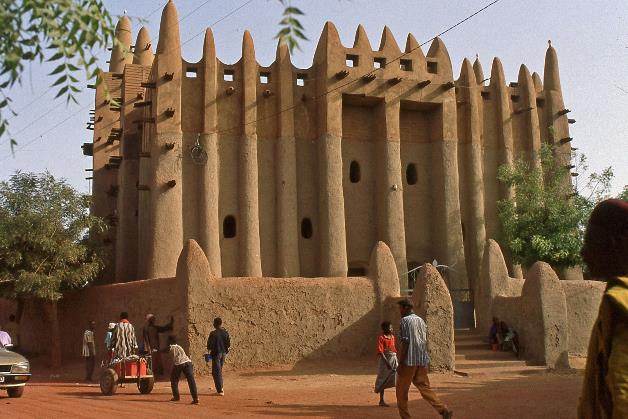
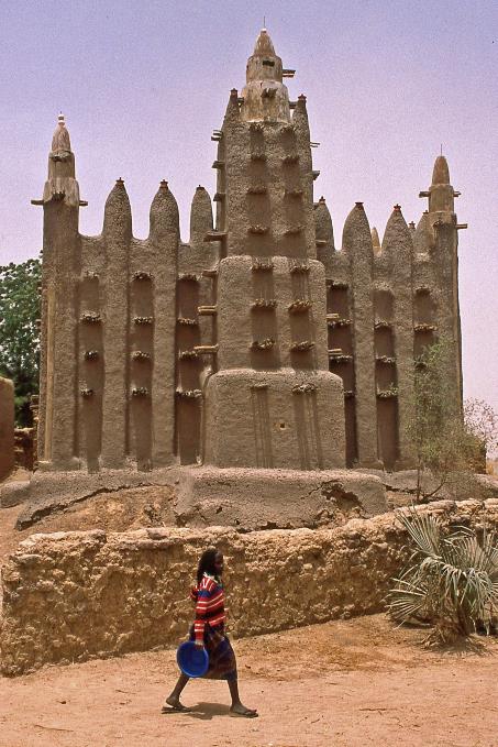
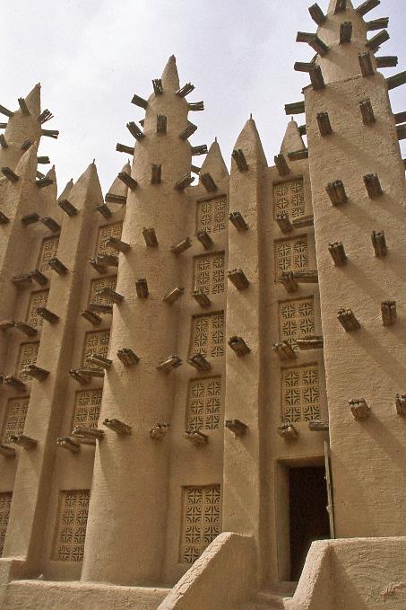
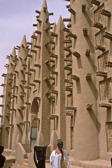
Embedded in the fabric of the old town, the mosque radiates perfect harmony with the old earthen architecture of this part of the city
Mopti – Skyline with the mosque of Komoguel
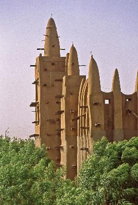
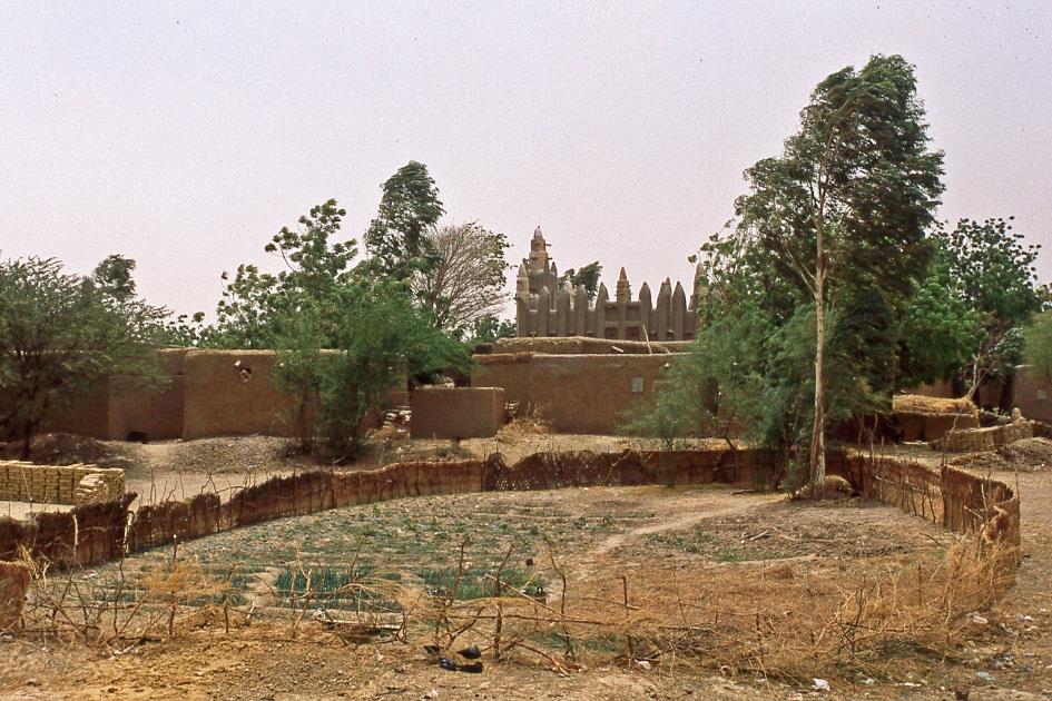
Although it rises high above its surroundings, the famous Mosque of Komoguel is somewhat hidden among the trees and the adobe houses of the old town. It is a fairly recent building, built in the 1930s on the site of a slightly older mosque. Like its world-famous example, the Great Mosque of Djenné, it is built in the Sudanese style with no building materials other than earth, straw and wood. Yet it is not a copy of it, because the front and back facade of the Komoguel mosque are identical, which makes it unique. In addition, the mosque is skewed on the rectangular street plan of the old city, as both facades point to the qibla, the direction in which Mecca is located.
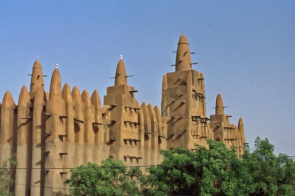
The Mosque of Komoguel is built in the Sudanese style with no building materials other than earth, straw and wood
It is not easy to get a good picture of the mosque. It is hardly possible to take a little distance to overlook the whole. You're almost right on top of it. But that is also the strength of this mosque. Embedded in the fabric of the old town, it radiates perfect harmony with the old earthen architecture of this part of the city. This mosque is alive, it is here that most of the faithful gather during Friday prayers.
|
|
|
The way in which people experience Islam here is less frenetic than elsewhere. There are no veils for women, let alone chadors or niqabs
The two central towers are fifteen metres high, which is quite an achievement for a mud building. Rain can do a lot of damage, because sun-dried building blocks have little resistance to water pouring down from the sky. In 1978 the mud walls therefore were covered with a protective cement layer. Unfortunately, the job was not done well. The mosque now urgently needs a new restoration2).
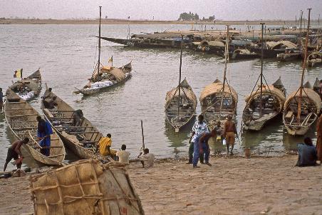
Mopti – Little harbour |
|
|
It was not until the 16th century – more than nine hundred years after Muhammad's first proclamations – that Islam reached these areas. For a long time, the animist population, especially the dominant tribe of the Bambara, held back the new religion. It would take nearly two centuries for Islam to gain a foothold. Even then, the way in which people experience Islam here is less frenetic than elsewhere. There are no veils for women, let alone chadors or niqabs. Women have managed to maintain their traditional social position, especially in the markets. Islam was often rather a binding agent of different ethnicities against the French colonial aggressor. Animism still plays an important role to this day, as witnessed by the social role of the marabouts, the spiritual counsellors.
|
|
|
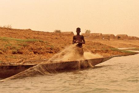
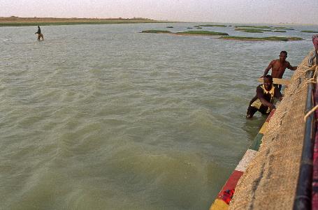
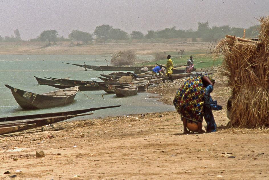
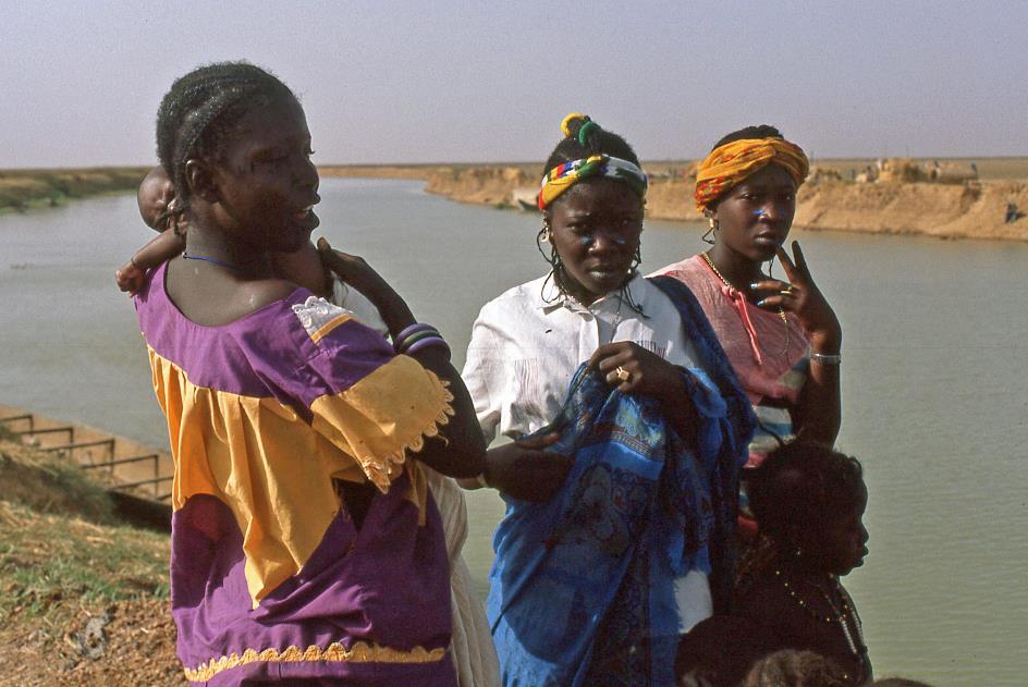
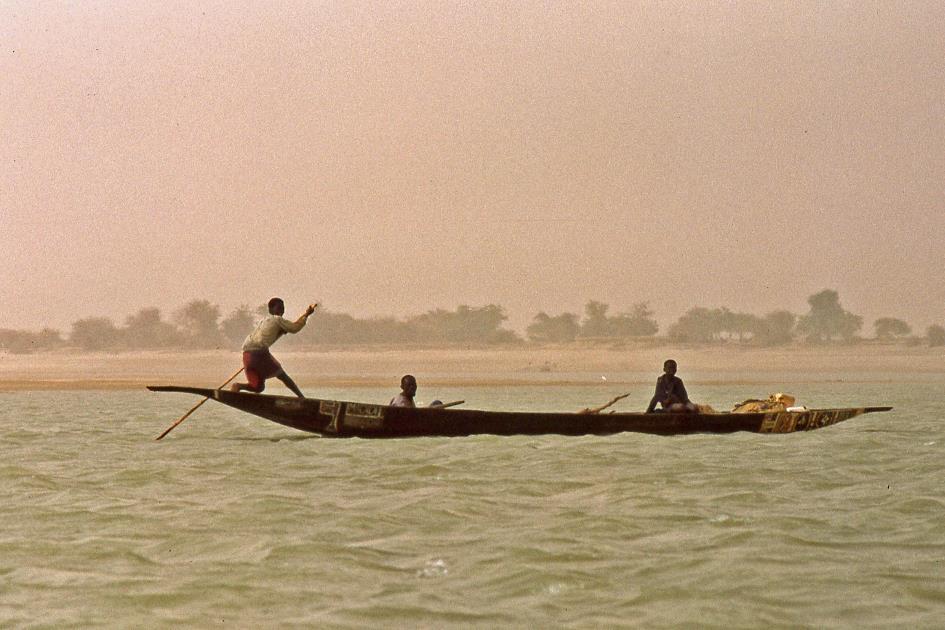
We stay on the waterfront for a while. The calm waters of the Bani twinkle in the light of the setting sun. In the little harbour the pirogues lie shoulder to shoulder alongside the quay. It is these long, narrow boats that make up most of the traffic on the river, both for transporting people and goods. Starting tomorrow, one of those pirogues will become our biotope for three days.
* * * * *
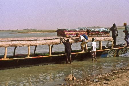
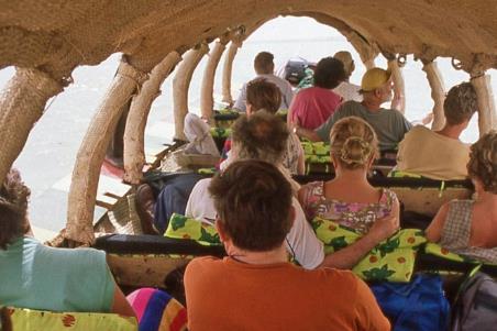
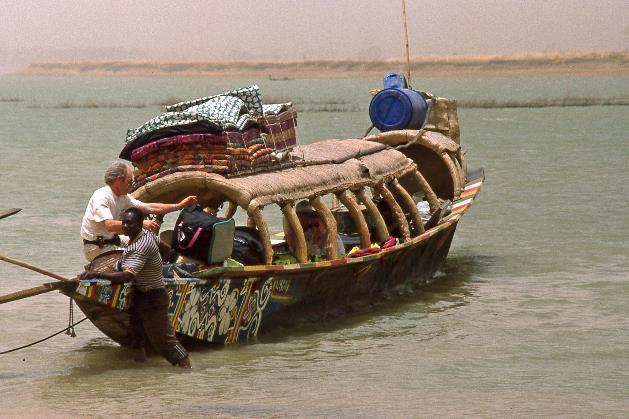
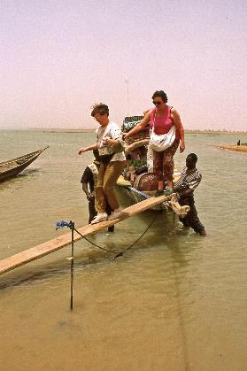
It's been a few days of anxious anticipation, but there it is at last, our pirogue. It turns out to be an oversized prahu, about twenty metres long, with a thatched roof almost the entire length. On the roof, there are some twenty mattresses lashed together. A large blue barrel at the back of the roof contains potable water. At least we suspect so. Inside, wooden benches can accommodate about fifteen passengers. The benches are fitted with cushions.
So much for the comfort. The benches take up the full width of the boat. So there is no room to walk around. Stay put will be the motto. We board via a narrow gangplank. We then shuffle sideways on the board plank on the outside of the boat to the rear until we reach our seat. There, with acrobatic panache, we lower ourselves into the passenger compartment.
It turns out to be an oversized prahu, about twenty metres long, with a thatched roof almost the entire length
Boarding the pirogue |
|
The captain |
Bailing water out of the pirogue |
|
The passengers |
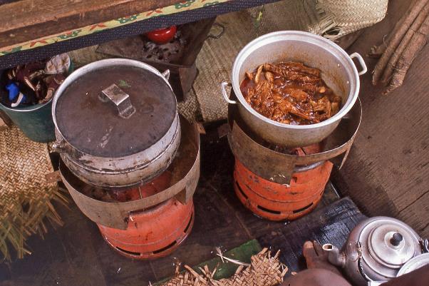
Further back is what we conveniently will call the kitchen – an open space with two butane gas bottles, each with a gas burner, and a mishmash of pots and pans, plates and cutlery. Gradually we will come to appreciate the simple yet exquisite meals that are produced in these primitive conditions.
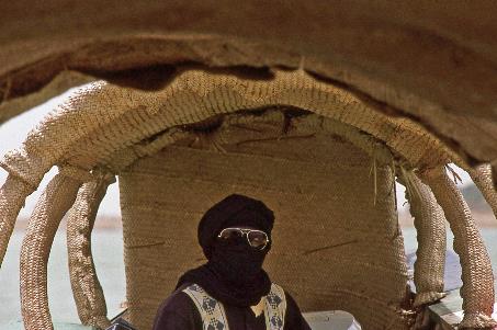
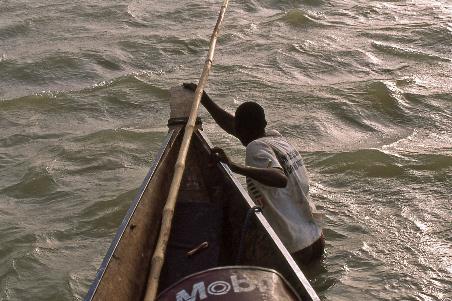
Even further back is what you might call the bridge of our boat, as this is where the captain sits. Imperturbable as a sphinx, he will sit here at the helm for hours. At least, as long as no problems arise. But there will be plenty of problems. We’ll soon learn that.
There will be plenty of problems. We’ll soon learn that
Finally, at the very back of the boat, out of sight of the passengers and crew, is one of the most important places in the pirogue – the toilet. Shielded by burlap bags, you can answer nature's call over a hole in the wooden floor. With a light thud, your product disappears in the Niger – where else? Just reaching the place is a little adventure. You climb out of the passenger compartment and shuffle sideways across the board plank while holding on as best you can to a bamboo pole on the roof. Once you have arrived in the confines of the smallest room you can only hope that the boat does not hit a sandbank just as you are in a precarious position.
|
|
|
By local standards this of course is a luxury boat. However, we are not completely convinced. And that has mainly to do with the weather conditions, more specifically with the scorching heat. At night the thermometer does not drop below 30 °C, during the day the mercury quickly rises to 40 to 45 °C. Even the locals struggle with the unusual heat. We can live with the fact that we have been without air conditioning for more than a week now. After all, you have to experience this country as it is. But for the next few days we won't have access to running water either and that will be a tougher one.
At night the thermometer does not drop below 30 °C, during the day the mercury quickly rises to 40 to 45 °C
As always, our regular escort Sory is in a good mood and busy helping people and goods getting on board. He is a Bambara and thus belongs to the main tribe of Mali. Over the past week he has proven to be a friendly person, a helpful devil-do-all who knows how to come up with a solution to every problem, although the creativity of his approach sometimes surprises us. He is thirty-eight now, while his fiancée is nineteen. Together they have twins who are… six years old. His 80-year-old father is quite upset about that, not because of the age difference, but because his only son still is not married.
And then there are the three crew members of the pirogue – the skipper, the boatboy and Moussa who turns out to be in charge of the expedition. All three belong to the Songhai. From the 14th to 16th century, the Songhai ruled a legendary kingdom that controlled almost the entire basin of the more than four thousand kilometres long Niger. It was they who introduced Islam to this area. Today, the Songhai mainly earn their living as fishermen and skippers. Not so long ago, they were also active as hippo hunters.
The Atlantic Ocean, the final destination of this river, may be in the south, but the Niger flows stubbornly north, straight into the largest desert on earth
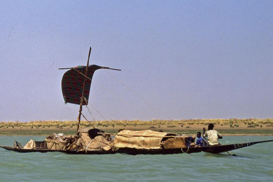
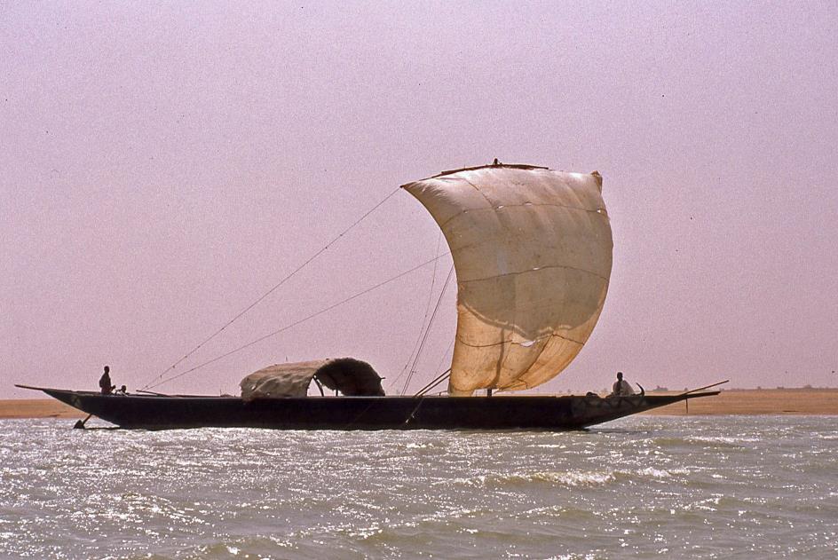
Pinasse with merchandise on the way to Mopti
Twenty past nine. Let's go, the adventure can start. Downstream we follow the Niger to the north. Yes, to the north. The Atlantic Ocean, the final destination of this river, may be in the south, but the Niger flows stubbornly north, straight into the largest desert on earth. A strange situation indeed.
The Sahara sometimes is a beautiful green savanna, then a bone-dry desert. That has been the case for at least seven million years
To understand that, we have to go far back in time. Because the Sahara hasn't always been what it is today. After all, the Earth's orbit around the sun has a series of oscillations. These change the climate in such a way that the Sahara is sometimes a beautiful green savanna, then a bone-dry desert. That has been the case for at least seven million years. The Sahara pump is what scientists call this mechanism.
In its green phases, the Sahara hardly differed from the savanna as we know it today in Kenya and Tanzania. You had grassy plains, trees, rivers and lakes, you met animals like gazelles, giraffes and elephants. And people too, because everywhere in the Sahara you will find rock paintings and petroglyphs where these animals have been immortalized. The Niger then flowed neatly to the north and emptied into one of the many lakes.
In the Inner Delta an agrarian culture developed that lives to the rhythm of the floods, just as the Mesopotamians and the Egyptians did on the banks of the Tigris, Euphrates and Nile
Temporary rice straw huts in the Inner Delta of the Niger
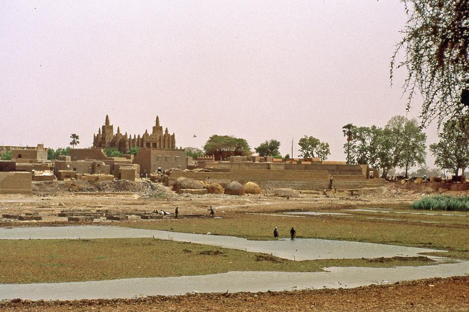
Eighteen thousand years ago, that changed. While in Europe we were experiencing the height of the last ice age, the Sahara was facing an extreme drought. The desertification was unstoppable. Near present-day Timbuktu, strong trade winds pushed forward the desert sands and built a wall of huge sand dunes. In the end, there was no more passage for the Niger. South of Timbuktu, it came to a stop. Gradually a new lake formed.
Ten thousand years ago, the pendulum swung to the green side again. And while this new green phase didn't last long, the consequences were far-reaching. The water in the lake kept rising until it finally spilled over the edge and continued on its way. This time not to the northeast, where dunes still blocked the passage, but to the southeast. And miraculously, there the Niger encountered another river that had been flowing southwards for millions of years. Henceforth, the Niger also would flow into the Atlantic Ocean.
Today we know the Sahara again as a huge, bone-dry desert. This dry phase started six thousand years ago. But for the Niger, that made no difference. The river had turned its back on the Sahara for good. The north-south bend the river makes today is known as the Niger Bend.
And the place where the lake used to be is now called the Inner Delta. This is a very special environment, because an agrarian culture developed there that lives to the rhythm of the floods. Just as the Mesopotamians and the Egyptians did on the banks of the Tigris, Euphrates and Nile. It is precisely these societies that are our destination.
Diamina – Mosque
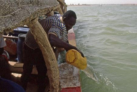
But for now, our concerns lie elsewhere. A light breeze blows tiny water droplets and sometimes whole ladles of water in our faces. We are not keen on that, because in the meantime we have a pretty good idea of what is in that water. In addition, there are some holes in the hull of the boat where water regularly gushes in as if they were miniature geysers. Attempts are being made to close those gaps with towels. In the back, Sory and the boatboy take turns trying to scoop water from the boat. The grinding noise their bucket makes as they scrape over and over on the wooden floor will haunt us even in our dreams.
A tight hot desert wind howls around our ears. The village seems to be permanently in a cloud of dust
It seems as if we are continuously being sandblasted by the hot air flow of a huge hair dryer
Eight years ago, this journey wouldn't even have happened. The Tuaregs in the desert provinces of Mali, Niger, Algeria and Libya felt constrained and abandoned by their governments since the 1980s. In 1990, their pursuit of greater autonomy led to an armed conflict that did not end until 1995. All this time you'd better not show yourself as a tourist here.
Vegetable garden with fence of reed mats
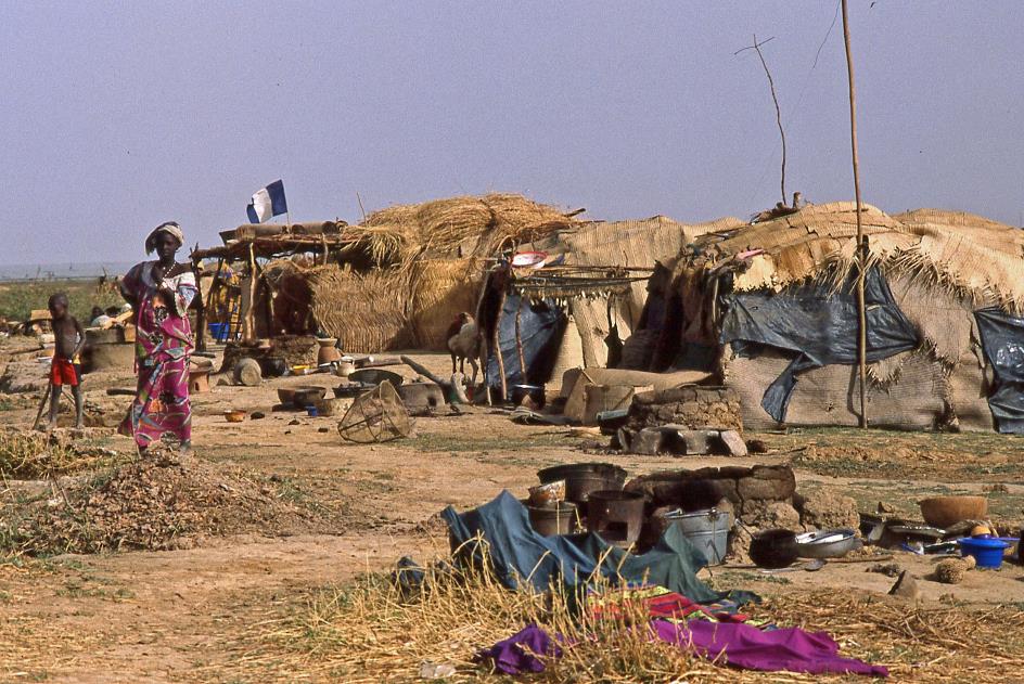
It is half past eleven when we reach Diamina, a village of Bozo and Fula where we go ashore. A tight hot desert wind howls around our ears. The village seems to be permanently in a cloud of dust. Trees lean backwards under the constant pressure of the wind, people lean forward against the wind. The sparse vegetable gardens on the edge of the village are surrounded by reed mats to protect the delicate plants from the unrelenting wind.
The instigator of all this is the Harmattan, the formidable desert wind from the northeast. During the winter months, it builds up over the Sahara and then heads for the low-pressure area over the Gulf of Guinea — not without scooping up a hefty load of tiny grains of sand along the way. In April, the Harmattan normally starts to weaken gradually, but for now that doesn't seem to be the case. It seems as if we are continuously being sandblasted by the hot air flow of a huge hair dryer.
Mosque |
|
Mudbrick houses with courtyard |
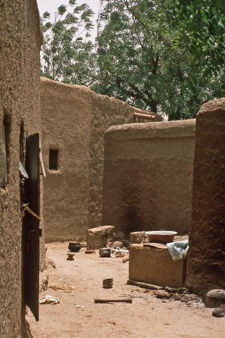
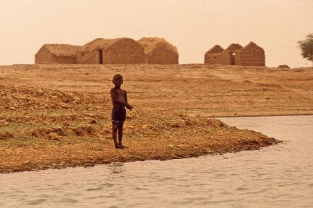
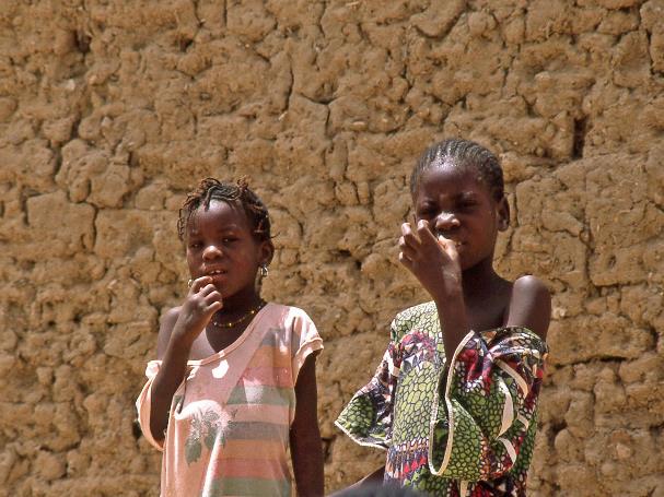
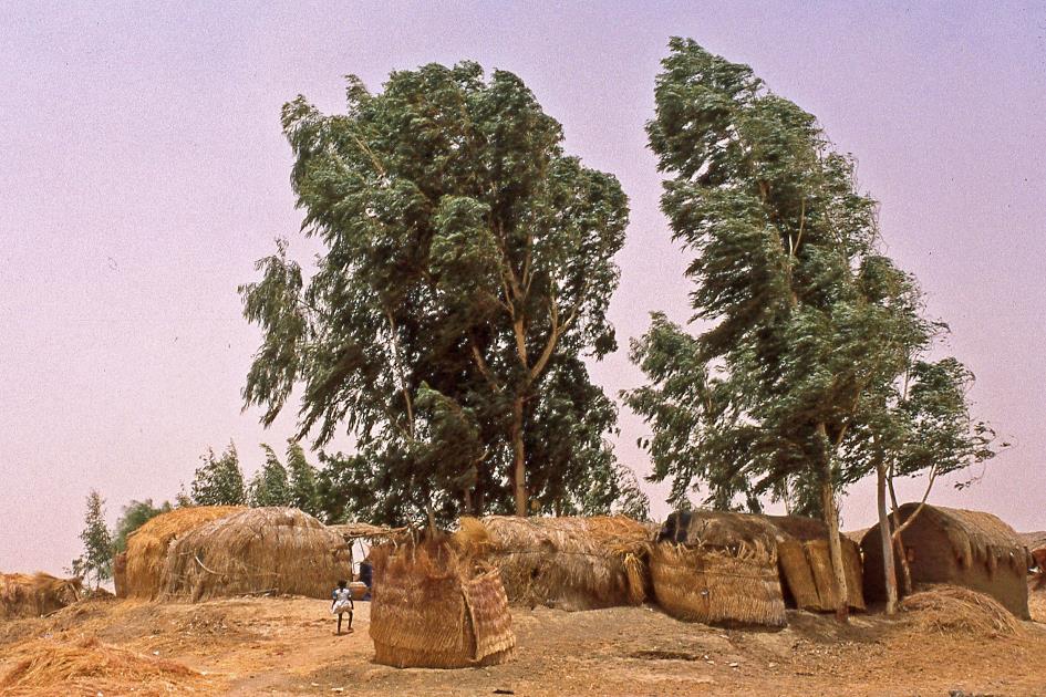
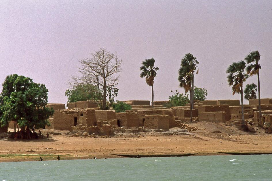
As in most villages along the Niger, the houses in Diamina are built of clay. Building materials other than wood, loam and straw simply are not available here. Between the houses we find a small, but beautiful mosque. Too bad that as non-Muslims we never are allowed to take a look inside. There aren't that many people on the street, it's way too hot this time of day. They look at us curiously, a bit shy, but their eyes are warm and their wide smile is genuine. We really can't imagine living and working here. But the harsh environment doesn't seem to affect their indestructible optimism.
|
|
|
The harsh environment doesn't seem to affect their indestructible optimism
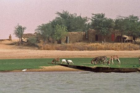
Closer to the riverside are the rice-straw huts where the Fula reside at this time of year, as the Fula are traditionally herders who travel with their livestock. The Bozo, on the other hand, are fishermen. For centuries, both peoples are living together in the same biotope, each in their own way, as if in an ethnic l.a.t.-relationship.
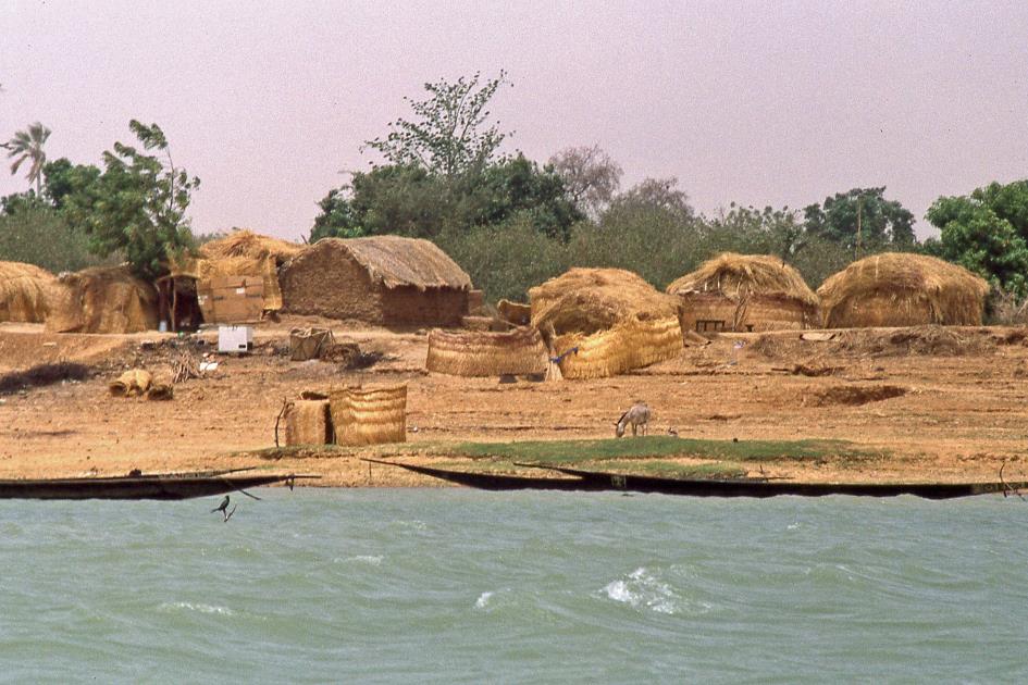
Temporary rice straw huts
Back on board, Moussa appears to have bought live chickens in the village. Plucked and cut in pieces, they promptly disappear into the cooking pots. That will be our first lunch. Anyway, our food couldn't be fresher. Despite the scorching heat, we don't have to worry about food spoilage. While Moussa skilfully stirs the chicken and couscous, the boatboy in the kitchen continues to bail out water incessantly. No unnecessary luxury, because in the kitchen the water around the butane gas bottles is still two centimetres high.
Cooking on board |
|
Butane gas bottles standing in the water |
Pepper and salt, Moussa is very generous with that. He has to, because through perspiration we lose more salt than is good for us. And pepper is an indispensable flavour enhancer in this heat to stimulate our appetite. It must be said, Moussa knows what he is doing. What he prepares tastes delicious.
Enthusiastically they wave their arms wide in the air until we are out of sight
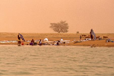
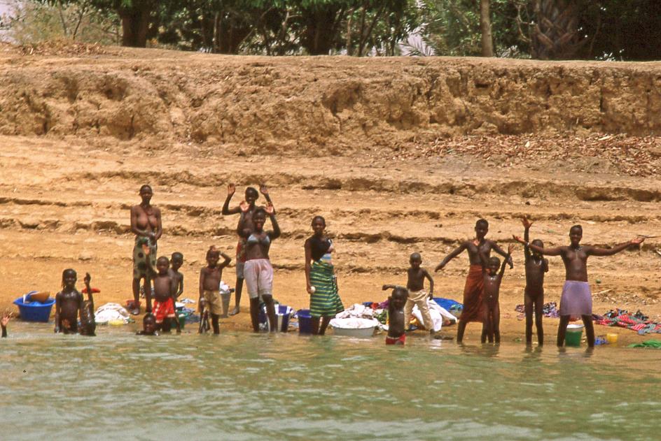
Meanwhile, the banks of the Niger slowly glide past. Every now and then a form of habitation shows up, often no more than a handful of mud houses with a few palm trees rising above them. Sometimes a group of women has descended to the bank. They have their children with them and are busy doing the laundry. Our exotic appearance is then invariably received with enthusiastic cheers, first of all from the children, but usually also from the women. Enthusiastically they wave their arms wide in the air until we are out of sight.
It is a heartwarming spectacle to experience so much energy, so much hospitality, so much joie de vivre despite the challenging circumstances. The joyful sound of those children's voices will continue to reverberate in our heads, even long after we're back in Europe.
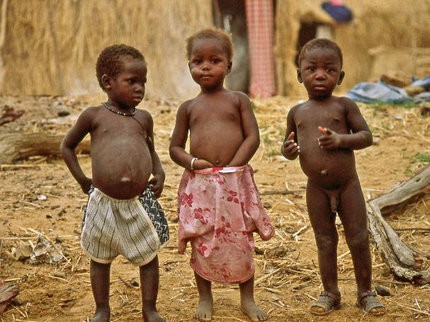
After all, let's not forget that Mali demographically3) is not doing well. It is counted among the poorest five countries in the world. On average, life expectancy is 44 years, partly because one in seven children does not live to be older than one year. As far as food is concerned, the average Malian needs to make do with no more than 70 % of the minimum calorie requirement every day. Barely 32 % of the population can read and write.
Mali is counted among the poorest five countries in the world
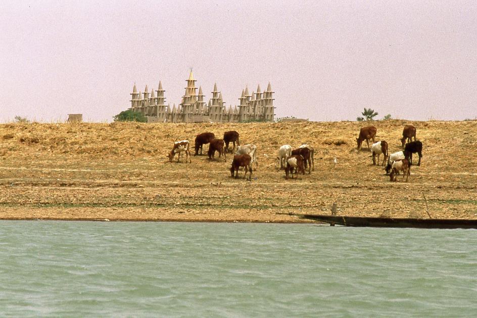
Kotaka – Mosque
Half an hour later, on our right, the impressive silhouette of a mud-brick mosque with its many towers rises above the steep riverbank. This must be Kotaka, a fairly large village, about fifty kilometres north of our starting point Mopti. It is sweltering hot and the Harmattan is raging.
|
|
|
But that doesn't stop us from going ashore, as the place is well worth it. If only because of the lively maze of authentic streets between the mud houses, the Fula women with their typical tattoos and beautiful jewellery, the cheerful children. And last but not least the impressive, well-maintained mosque. Unfortunately, here too the rule applies that non-Muslims are denied access to the house of worship. As a consolation, an old man shows his six-fingered hand.
|
|
|
|
|
Back on board, a proud Moussa has some good news. Local skippers took advantage of the short delay to plug some holes in the boat. Great, our future even looks drier than before.
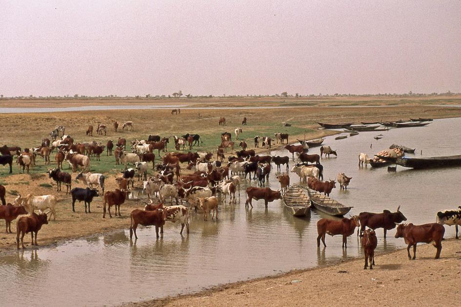
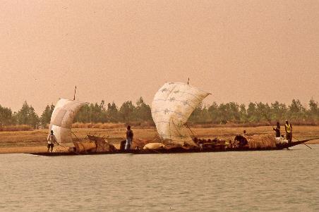
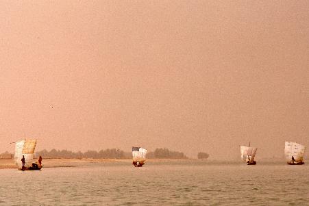
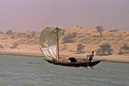
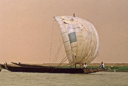
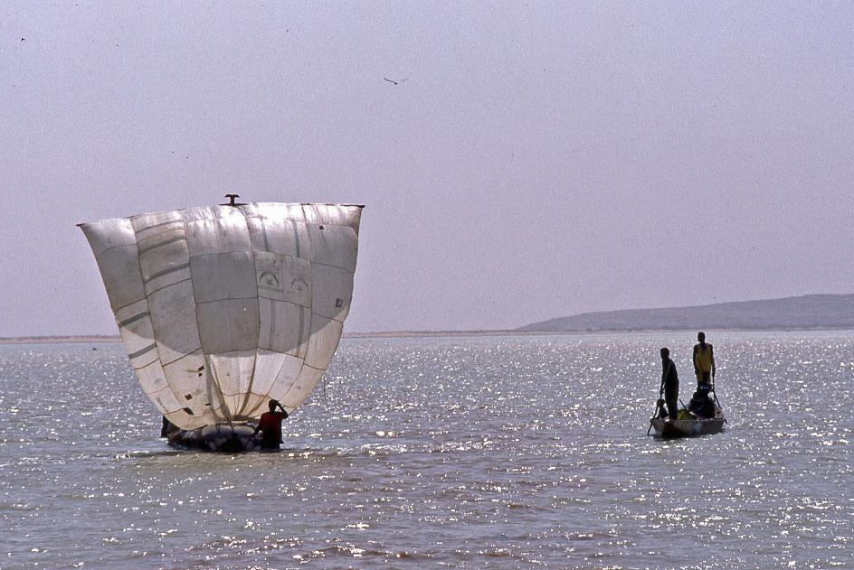
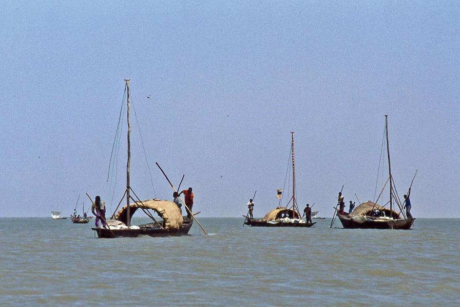
Life on and around the river goes on as usual. Cows graze in small herds, women do the laundry, fishermen cast their nets, donkey carts on two wheels carry their modest loads. On the river, it's the heavily loaded pinasses that steal the show. With their large billowed sails they sail swiftly against the current of the Niger, propelled by the mighty Harmattan, to sell their merchandise in Mopti.
|
|
|
With their large billowed sails they sail swiftly against the current of the Niger, propelled by the mighty Harmattan, to sell their merchandise in Mopti
In the meantime we have become aware of another effect of the Harmattan, one that we see starting at noon on the horizon in the north. The sky turns orange-red. Little by little, this discolouration extends southward, as if an orange-red curtain is being drawn across the blue sky. The operation will be completed around four o'clock in the afternoon. From that moment on it seems as if the whole world has been drenched in an orange-red liquid.
|
|
|
It seems as if the whole world has been drenched in an orange-red liquid
It is of course the fine desert sand, whipped by the Harmattan, that gives this colour to the landscape. Even the sun turns pale. Although there isn't a cloud in the sky right now, the solar disk is barely brighter than a full moon on a crystal-clear night. So it will also be a bit fresher, you would think. None of that, it stays sweltering hot.
|
|
|
But there's more. All those sand particles in the air affect people's health. They cause respiratory problems and affect the mucous membranes. This, in turn, leads to an increased risk of meningococcal disease. Scientists even speak of an African cerebrospinal meningitis belt. Stretching south of the Sahara, from Senegal in the west to Ethiopia in the east, it frequently is the scene of a meningitis epidemic. A dramatic peak was reached two years ago [1996], when three hundred thousand people were affected by the disease, of whom thirty thousand died. For us there is no real danger, but for the locals that is an extra challenge in this demanding environment.
Scientists even speak of an African cerebrospinal meningitis belt
Shortly after four, some hippos make their appearance. Before we have seen them properly, they have disappeared under water. So the Songhai have not completely wiped out the hippos and the Niger is quite deep here, we conclude. The first conclusion is correct, the second is wrong. Barely five minutes later, the boat comes to a stop with a grinding noise. It's the first time we get stuck in a shallow strip. What we don't know yet is that the problem of the low water level of the Niger will gradually turn into a nightmare.
For now there is nothing wrong. Moussa, Sory and the boatboy lower themselves into the water and have the pirogue freed from its precarious position in the blink of an eye. A few minutes later we continue our trip. Even more cautiously than before, the skipper now navigates through the shallow water. That doesn't prevent us from getting stuck again half an hour later.
The low water level of the Niger will gradually turn into a nightmare
It will become a familiar ritual for the crew – getting stuck in shallow waters, turning off the engine and tilting it, lowering themselves into the water, pulling and towing the pirogue to free it, manoeuvring backwards with the boat against the river current, looking for a deeper channel, piloting the boat to that fairway, anxiously waiting to see if it will work this time. Sometimes one attempt will do, sometimes two, three or four attempts are needed. Sometimes the whole process takes five minutes, sometimes thirty. In between, the bailing of water from the boat continues unabated. Which begs the question, weren’t those holes plugged in Kotaka?
It is already six o'clock in the evening when we moor at some huts. It is not a permanent settlement, but a nomadic fishing village of Bozo. Depending on the presence of fish, they move their camp along the river. Apparently Moussa feels at home everywhere along the river. He barely is ashore when he has a child on his arm. It soon becomes clear what the purpose of our short visit is – a few chickens and portions of dry fish are brought on board.
More than half an hour later we moor at a fairly steep bank. This will be our first overnight stay on the banks of the Niger. Welcome to l'Auberge du Fleuve, as Sory describes the place in a lyrical mood. Apparently two dromedaries also wanted to spend the night here, but promptly flee as soon as we go ashore.
Welcome to l'Auberge du Fleuve, as Sory describes the place in a lyrical mood
Temporary fishing village of Bozo |
|
L’Auberge du Fleuve |
In the semi-darkness we set up our tents on the hard sandy ground. The Harmattan has calmed down, for now there is only a light wind. Just after eight, Moussa has dinner ready: spaghetti with fish sauce, as always simple but tasty. Two light bulbs, connected to a roaring diesel generator, shed some light into the darkness.
A cloudless night in the desert, far from any kind of artificial light. That's all you need to enjoy a beautiful starry sky. In theory at least, because even now the ever-present sand fog makes itself felt. Not a single star can be seen further than 60° from the zenith. Even in the zenith there are significantly fewer stars to be seen than you would normally expect.
* * * * *
Six o'clock. A whistle brings the camp to life. The tents are quickly dismantled and the campsite is evacuated. A little over half an hour later we are on board our pirogue. Out of necessity, morning hygiene rituals are kept to the absolute minimum, partly because we have to hurry, partly because we simply don't have more than half a bucket of water for the whole group. We have breakfast on board so as not to lose time.
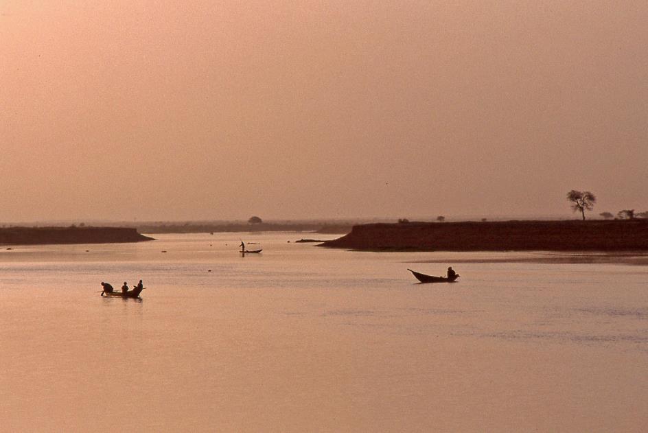
In the morning twilight it is teeming with the small vessels of early fishermen on the river
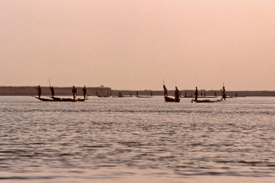
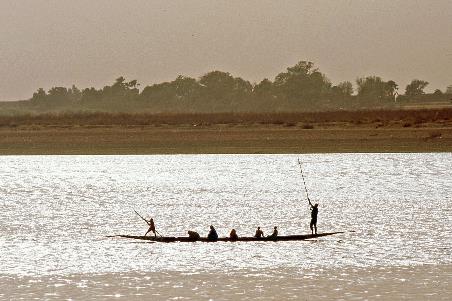
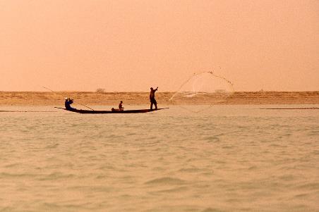
The Harmattan has yet to awaken, the sun, on the other hand, is already completely out. In the morning twilight it is teeming with small vessels of early fishermen on the river. It must be the best time of day to catch fish, otherwise there wouldn't be that many. Usually the two of them are in a pinasse – in front a man with a long stick to push the vessel through the shallows, in the back a man with a fishing net. What they catch is mainly used for their own food supply. Fish simply is the main ingredient of their little varied diet. If possible, they also try to sell part of their catch.
Capitaine (Nile perch) |
|
|
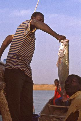
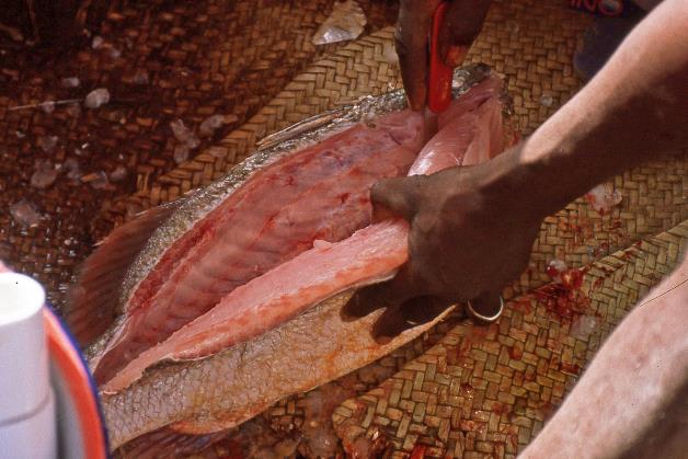
Moussa boards one of the pinasses to buy some fish. There is some bargaining, after which Sory is given two capitaines, the local name for Nile perch. They are real champs, one of half a metre and one of eighty centimetres. That will be our lunch. But first we have breakfast, while Sory starts to fillet both fish.
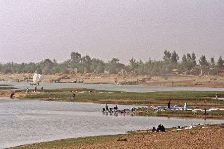
By eight o'clock all the fishermen have disappeared from the scene. It is a bit quieter on the river now. On the river banks, on the other hand, it is getting busier. The cool morning hours lend themselves better to outdoor jobs – if you can call temperatures above thirty cool. Again and again we pass groups of women and children at the traditional washing places, again and again they start waving and cheering as soon as they notice us.
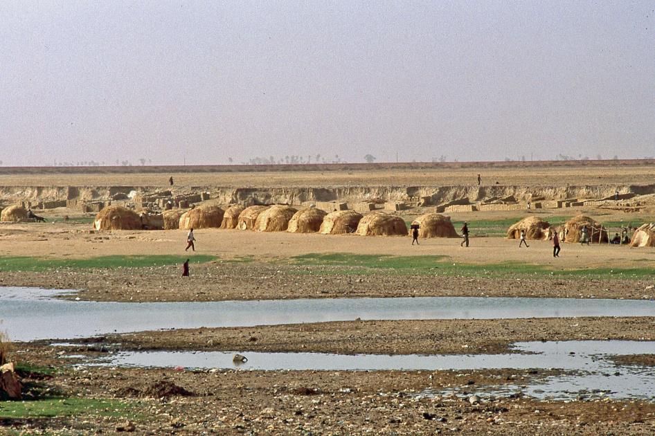
Then a large nomadic settlement of both Bozo and Fula shows up. This will be our first introduction to the Inner Delta of the Niger
Nomadic Bozo
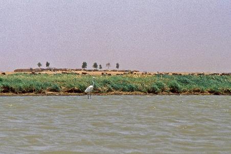
Then a large nomadic settlement of both Bozo and Fula shows up. This will be our first introduction to the Inner Delta of the Niger. This is where a lake, twice the size of Belgium, formed eighteen thousand years ago, because the Niger was held back by the huge sand dunes of the Sahara. Today this is West Africa's largest wetland, which owes its fertile status to the annual floods.
It's not the local rains that cause these floods – although they contribute too – it's tropical rains a thousand kilometres from here over the rainforests of Guinea, Ivory Coast and southern Mali that are causing this deluge. From late May to early June, the Niger begins to swell. This continues until the end of October, when the water level reaches its highest level. The recession starts in November.
During the wet season, this area will be completely under water
This natural form of irrigation gives the vegetation an enormous boost. But due to the many unevennesses in the terrain, this does not happen evenly. Low-lying areas are flooded every year. Higher areas form islands that are never submerged and can be permanently inhabited. And in between there are zones that sometimes flood, sometimes don't.
That doesn't make things any easier when you have to decide where and when to plant which crops – sorghum, pearl millet, red rice, etc. The latter is also called floating rice because it can withstand the floods. Planting is done in June, so that the stems are thirty to forty centimetres long when the floodwaters arrive. As the water level rises, the plants grow three to five metres in height. The rice is then harvested in December… by canoe.
For the locals, this is not the Inner Delta of the Niger, but the Bourgou
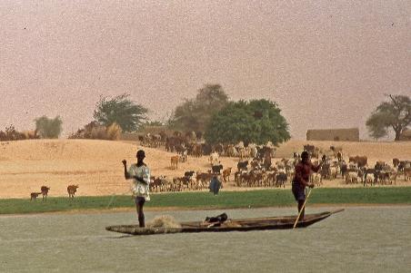
Livestock farmers such as the Fula, on the other hand, are mainly interested in the low-lying zones. Because only there grows the famous bourgou, a grass that is particularly nutritious for their livestock. In the dry season, even from locations as far as Burkina Faso and Mauritania, nomadic herders show up here to graze their livestock. The area also owes its local name to it. For the locals, this is not the Inner Delta of the Niger, but the Bourgou.
Bozo women |
|
|
During the wet season, it is mainly the Bozo that are active here. As fishermen, they then feel at home. However, that it would be easier to catch fish during the floods is too short-sighted. There may be many more fish in the water then, but it can also spread over a much larger area. Yet it is thanks to the Bozo that the Bourgou is the largest freshwater fishery in West Africa. Eighty to ninety percent of Malian production comes from here.
We stroll through the busy settlement. It is exclusively women and children that we meet. Close to the river they mainly belong to the Bozo, further inland to the Fula. The huts are all very primitive, for they are only temporary. During the wet season, this area will be completely under water. Moussa estimates the number of Fula in Mali at one million, the number of Bozo at one hundred and fifty thousand4).
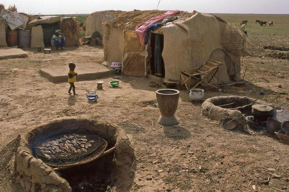
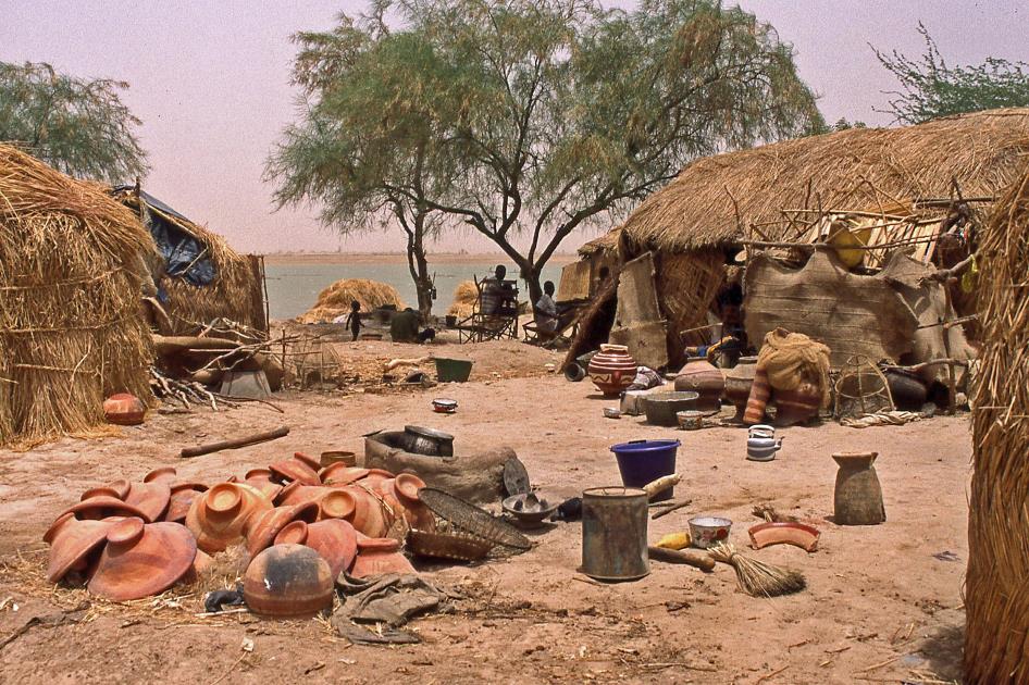
Various fish species – carp, Nile perch, catfish – hang to dry between metal grates over the smoky fire
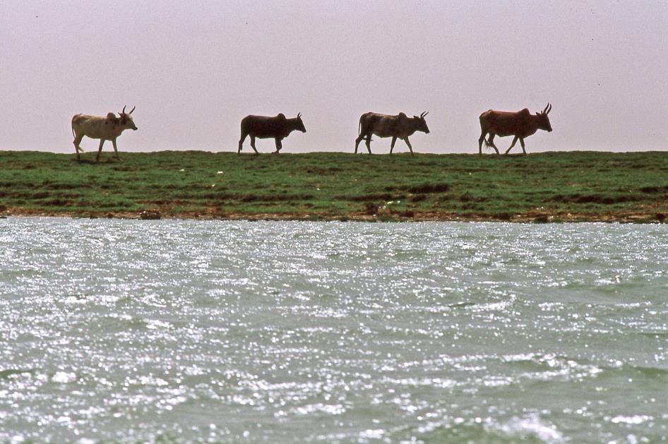
With the Bozo we notice the countless round fireplaces made of loam stone. Various fish species – carp, Nile perch, catfish – hang to dry between metal grates over the smoky fire. With the Fula, it is the zebus who attract attention with their impressive horns and their characteristic hump behind the neck.
Nomadic Fula with their cattle
Once the water level starts to rise – in a few weeks' time – the Fula will move their herds to pastures in higher elevations in the south. That is a journey of hundreds of kilometres. This has been the case here since the 14th century when the Fula descended on this fertile area. The festivities associated with this annual cattle migration – the yaaral and the degal – have been recognized by UNESCO as Intangible Cultural Heritage.
In a demanding biotope such as this, access to food sources is of vital importance

A harmonious coexistence, it seems, of two communities strongly complementary in their actions. Yet the social organization in this area is extremely precarious. After all, in a demanding biotope such as this, access to food sources is of vital importance. With the Bozo, it is the dji-tigui, the master of the waters, who decides who can fish where. With the Fula it is the jooro, the master of the land. It is he who allocates the low-lying, fertile strips, the so-called bourgoutières, to the candidates. Unfortunately, customary law is at odds with the laws of the Malian government. And not everyone even agrees on the interpretation of customary law. In 1993, this led to a conflict that killed 29 people. The bourgoutière to which the dispute related was barely two hectares in size.
Fula women |
|
|
But our concerns lie elsewhere. We have been ashore for no more than half an hour. Yet the skipper has become nervous of the loss of time. How many kilometres we still have to travel, we don't know. How long that will take, we don't know. According to schedule we should arrive in Timbuktu tomorrow morning, where breakfast will be waiting for us.
Lake Débo is the main remnant of the huge lake that formed here eighteen thousand years ago
Then about nine o'clock Lake Débo looms, the main remnant of the huge lake that formed here eighteen thousand years ago when the Niger could no longer flow northwards. In the north, as far as the eye can see, there's only water to be seen. Such a huge body of water can only be associated with coolness. Wrong again. It remains sweltering hot on board. This may have to do with the reflection of the sun's rays on the water surface. We shouldn't have any illusions about the depth of the water either. We are barely on the lake when the bottom of the boat rubs against some boulders. When Moussa disembarks to free the boat, the water doesn't even reach his knees.
Most pirogues have lowered their sails. With long sticks people push their boats forward on the shallow bottom
It will be an arduous quest to find water channels deep enough to continue our journey. Sailing with billowing sails does not seem to work either. Most pirogues have lowered their sails. With long sticks people push their boats forward on the shallow bottom. Moussa is regularly forced to use the same technique. We cannot tell how far we are making progress. There simply are no reference points, we only see water. Undoubtedly, we're proceeding very slowly.
Then large grass islands appear on either side of the lake. For zebus these are little paradises. Often there are hundreds of them grazing. Surprisingly, a subtle wind from the southeast now seems to bring some coolness. The weather is still clear, with an open horizon. The Harmattan is not yet running at full throttle.
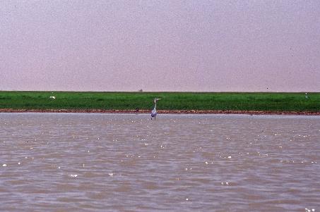
Great egret |
|
Grey heron |
Then suddenly the monotony is broken with a loud splash. A capitaine made a fatal mistake in his air flip and lands with a heavy thud on the floor of the boat. Sory reacts quickly and catches the unfortunate fish before we even realize what's going on. He leaves no doubt about the destination of the fish. He already has the knife at the ready.
The skipper knows the river like the back of his hand, he's used to sailing in the dark
Just after noon we reach the northern end of the lake. It took us more than three hours to cross Lake Débo. On our primitive map we can now roughly estimate our position. It seems we needed a day and a half of sailing to complete about a third of the journey. If we still want to arrive in Timbuktu tomorrow morning, we have to cover the remaining two thirds in half a day. That is a mission impossible. In addition, we have to take the plane to Bamako early in the morning the day after tomorrow. Even that part of our trip seems to be in jeopardy now. We will never reach Timbuktu in time. That's the only thought that crosses our minds during lunch, while the mud dwellings of Aka glide by on the right bank.
The skipper is getting more and more nervous. Let's sail until half past nine tonight, he suggests. We don't have to worry, he knows the river like the back of his hand, he's used to sailing in the dark. We are not very enthusiastic about his proposal, but the promise that we will arrive in Timbuktu tomorrow afternoon makes it acceptable. Just before three o'clock we sail between Pic and Attara.
Finally, there it is, at the mouth of the Koram – the dreaded Harmattan. From about four o'clock the gigantic hot air cannon from the northeast starts to blow tiny grains of sand and atomized drops of water in our faces again.
Quarter to six. For the first time, the skipper provides clarity about the sailing schedule that we have ahead of us. Three more hours to Niafunké, then another five hours to Diré, then another six hours to Timbuktu. Fourteen hours of sailing altogether, assuming we don't get stuck again. Whether it is realistic to expect not to get stuck, we want to know. No, is the deadly honest answer. More specifically, between Niafunké and Diré we still have some nasty stretches ahead of us. At the end we will have sailed four hundred kilometres from Mopti to Timbuktu. That is the distance from Brussels to Dijon as the crow flies.
We will never reach Timbuktu in time. That's the only thought that crosses our minds
Shallow waters |
|
|
It must be said, since we left Lake Débo behind us, we have had much less trouble with shallow water. But now bad luck strikes again. When Moussa gets out of the boat, the water doesn't even reach halfway to his knees. There's no getting through for the pirogue. Turning around and looking for a deeper channel is the only solution. That works, but this single manoeuvre again takes twenty-five minutes.
In complete darkness we sail into the nets of a fisherman
Half past seven. In complete darkness we sail into the nets of a fisherman. For a moment we fear that the man will burst into anger – that would certainly be the case in Europe – but that does not seem to be happening here. Just turn off the engine, drift with the current for a while and then continue on your way. That's all. Everyone happy. All the while, in the kitchen, the bailing of water out of the boat and the preparation of food continues unabated. There are still things we can be sure of on board.
A little later we are on a collision course with fishing nets again, but the skipper manages to stop in time. The fisherman helpfully points out the position of his nets with his flashlight. Slaloming, the skipper steers our pirogue between the nets. There is complete silence on board as we enjoy the sounds of the night – the chirping of crickets, the moaning of the wooden wall of the pirogue, the scraping of a plastic bucket across the floor, the humming of the outboard motor.
Eight o'clock. We moor in Niafunké. Eleven more hours to Timbuktu, if all goes well. Sory and the boatboy immediately set out to buy supplies. Meanwhile, by the light of two bulbs, our dinner is served – spaghetti, chicken, sauce. Then we wait for the boys. It takes over an hour and a half for them to emerge from the darkness. But their search yields little, which is why it took them so long.
Huts, boats and people are reduced to black silhouettes against a bluish background
In the east, meanwhile, the moon has appeared on the horizon in its last quarter. Gently the calm waters of the Niger twinkle under the faint glow of the moonlight. Huts, boats and people are reduced to black silhouettes against a bluish background. There is hardly any traffic on the river. For an hour and a half we sail relaxed over the smooth water through the African night.
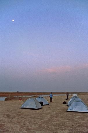
It is already past eleven o'clock when we finally go ashore. Together we set up the tents, gratefully taking advantage of the dim moonlight. It is a quarter to midnight when calm descends over the camp.
* * * * *
Barely five hours later, a shrill whistle sounds through the camp. It's a quarter to five, time to get up. Half asleep we disassemble the tents in the dim light of the moon that is now high in the sky.
The supplies on board are not meant for a three-day voyage. So there is no other option but to ration the food and mineral water on board
We set off at half past five. It is quiet on the river, even the fishermen are not at work yet. Having ten to eleven hours of sailing ahead, we hope to arrive in Timbuktu around four o'clock in the afternoon. But the supplies on board are not meant for a three-day voyage. And last night we did not manage to buy new supplies in Niafunké. So there is no other option but to ration the food and mineral water on board.
But we are moving fast now, very fast indeed. At full speed, the skipper steers his pirogue across the river, the water splashing all around us. When the first fishermen show up in their pinasses at six o'clock, they look surprised to see us speeding by at this early hour. Everything is going well. At least, that's what we keep thinking against our better judgement. Then, a little later during breakfast, we can put that illusion aside as we come to a grinding halt over some boulders. Moussa, Sory and the boatboy keep their spirits up and go into the water again and again. But often it is a long search before they find a navigable channel between the boulders.
Once the boulders are behind us, the skipper gives full throttle again. Now he can even engage both outboard motors. Our momentum seems unstoppable. The bow splits through the water, the waves make the water splash high, the fierce headwind pushes more and more water into the boat. One man can't handle the bailing anymore, Sory and the boatboy are now bailing shoulder to shoulder.
In the past you could find manatees almost all along the length of the Niger
The Niger must be quite deep here. This is not only apparent from the speed we can develop, but also from the presence of a few hippos. With great suspicion they watch us penetrate their territory. Promptly they dive under water.
Down there they may have the company of manatees, who knows. In the past you could find manatees almost all along the length of the Niger. How many of these benign mammals still live in the river today is unknown. They live permanently underwater, only to resurface occasionally to breathe. In the course of evolution, their hind legs have developed into a tail with which they propel themselves through the water. The Songhai, in particular, hunted manatees for their meat, their fat, their skin and even their bones. Of all manatees worldwide, the West African are the most endangered species.
|
|
|
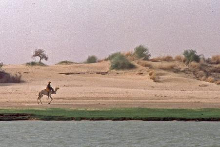
We regularly pass some islands where the Fula can go with their cattle. Dozens of cattle often graze there, sometimes there are some goats too. Yet the riverbanks are increasingly beginning to show the character of a desert. There’s no grass growing on the high sand dunes, only shrubs and some solitary trees manage to survive. In the foreground a Tuareg on a dromedary passes by. At one of those islands we stop to buy some fresh fish.
|
|
|
An hour later than planned, at half past eleven, we finally pass Diré. We still have at least six hours of sailing to go. When lunch arrives a little later, it surprisingly turns out not to be fish, but chicken with couscous and sauce.
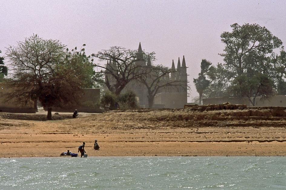
Sadji Lambou is a village of Songhai, the traditional hippo hunters
Sadji Lambou |
|
|
Despite the pressure of time, we are still interested in what is happening on the riverbanks. We will visit Sadji Lambou, a village of Songhai, the traditional hippo hunters. Peoples such as the Bozo, the Fula and the Songhai live together peacefully, but each in their own villages. That's the way of life here on the banks of the Niger. In addition, there are full-time nomads such as the Tuareg who pitch their tents wherever they please.
Songhai women |
|
|
|
|
It's sweltering hot ashore, even hotter than aboard our pirogue. Sadji Lambou turns out to be an enchanting maze of walled clay houses with a nice mosque in the centre. Soon women and children crowd around us. As always, the men are working elsewhere. For a moment there is some tension in the air. Everyone explicitly wants to be photographed and wants to be paid for it. But that atmosphere quickly drops when curiosity and hospitality get the upper hand.
Songhai women |
|
|
Back on board it is business as usual. Barely two minutes after we set sail, we get stuck. It won't be the last time today. Meanwhile, the sand haze is developing once again on the northern horizon. For the next few hours, it will completely engulf the landscape and shroud it in an orange-red haze.
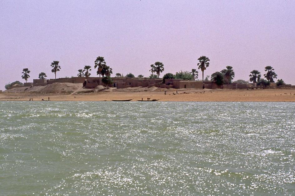
What Ostia was to Rome and Piraeus to Athens, Kabara was to Timbuktu
Six o'clock. In the west, the sun has almost disappeared behind the horizon. We dock in Kabara. Will this be another delay? No, this is our final destination. What Ostia was to Rome and Piraeus to Athens, Kabara was to Timbuktu – the port that was the hub of the city's economic activity. Apparently our four-hundred-kilometre boat trip has come to an end after all – a hallucinatory and gruelling, but fascinating eye-opener. While the boatboy continues to bail out tirelessly, we leave the pirogue for good.
Strictly speaking, it is not Kabara where we go ashore, but Korioumé. Kabara can only be reached by boat at high tide, which means in the months of December and January. But let's face it, we don't take offense that our pirogue can't take us all the way to the end.
Two jeeps are ready to take us to Timbuktu, eighteen kilometres to the north. Initially we drive on a paved dike road between eucalyptus trees, but soon it turns into a paved road through the desert. We arrive in Timbuktu in quasi-darkness. According to plan we should have reached our final destination this morning and we would have paid an extensive visit to the city after breakfast.
|
|
|
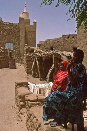
As the muezzin launches his call for the last prayer, we begin our visit. We stroll through the dusty, unlit sand streets to the centre of town. Many adobe cottages have their doors wide open, trying to let a little evening coolness penetrate into the rooms. These wooden doors are often artfully crafted and undoubtedly very beautiful. At least in daylight.
You could pay for a kilogram of salt with a kilogram of gold
This sandy Timbuktu was once considered one of the wealthiest cities in West Africa. The remote desert city owed that reputation solely to its strategic location. For north of Timbuktu stretches the vast Sahara. Climate change that started six thousand years ago led to the desertification of that area, but also to the drying out of the lakes. This created huge white salt flats, where salt is readily available. Salt was a highly sought after and therefore expensive product. If you wanted to store food at high temperatures for a long time, there was no other way than to use salt. The salt would dry out the bacteria and prevent the food from decaying.
One of the places where huge salt deposits could be found is Taoudenni, about 660 km north of Timbuktu as the crow flies. Twice a year a caravan travelled from Timbuktu to Taoudenni to supply the workers there – three weeks one way. On return, each dromedary had four or five plates of about thirty kilograms of salt on its back. The Azalai, that's what they called these caravans. The large Azalai left at the beginning of the cool season in November, the small Azalai at the beginning of the hot season in March.
It must have been a spectacular sight to see the great Azalai leave. At its peak, the caravan numbered no less than twelve thousand dromedaries. Twelve thousand, a number you simply can't imagine. Just think of the logistical problems – all those animals and people had to get enough food and especially water for weeks.
In Timbuktu, the salt from the north was mainly exchanged for gold, ivory and slaves. These products came from the tropical south and found their way to Timbuktu via the Niger. Salt travelled the opposite direction. Incidentally, salt was considered as precious as gold. You could pay for a kilogram of salt with a kilogram of gold.
At its peak, the big Azalai, the caravan from Timbuktu to Taoudenni numbered no less than twelve thousand dromedaries
But Timbuktu grew into much more than just a transhipment port for expensive merchandise. The rapid economic growth attracted Islamic scholars from far and wide. With its fifty thousand inhabitants, Timbuktu rivalled what was then London in 1500. From the 13th to the 17th century, the city was no less than a world centre of Islamic learning. Art and science, but especially religion, mathematics and astronomy were the focus. Gradually, owning books became a symbol of wealth, power and status. The many, often exclusive manuscripts gave Timbuktu a new halo. Today there must be about seven hundred thousand manuscripts, spread over various institutions5).
That prosperity came to an end when the Portuguese began to explore the coasts of West Africa. The Portuguese went on the spot to collect the ivory and especially the slaves and gold, and thus avoided the expensive trans-Saharan trade.
In the meantime we have arrived at one of the three large mosques, the Djinguereber. It was built about 1325, making it one of the oldest mosques in Africa. For nearly seven centuries, this adobe building has withstood sun and rain. During Friday prayers, two thousand believers can gather here.
Not far from the mosque we find the home of Alexander Gordon Laing, the Scottish explorer who was the first European to reach Timbuktu in 1826, all the way across the Sahara. That was quite an achievement, because people in Europe didn't even know exactly where the city was. But the locals didn't like strangers living in the city. Laing saw the storm coming and left after about five weeks. Too late, it turned out, Tuaregs got hold of him anyway and strangled him.
With its fifty thousand inhabitants, Timbuktu rivalled what was then London in 1500
René Caillié fared better two years later. Not only did he manage to stay in Timbuktu for two weeks, disguised as Tuareg, but he was also able to tell the story afterwards. Therefore it was he, and not Laing, who was awarded the prize of nine thousand francs from the French Société Géographique for being the first to provide reliable information about Timbuktu.
We conclude with a visit to the museum, or at least the outside, as the museum itself is of course closed. If we are to believe one of the many legends, this is where the well from which the city takes its name is located. Because at a time when Timbuktu was not yet a permanent settlement, there was a small oasis around a well. This was vital for the caravans. It was a certain Mrs Boektoe who held sway over this oasis. And since Tuaregs call a well tim...
* * * * *
Just before six o'clock in the morning the jeeps drop us off at Timbuktu airport. The sun has not yet risen above the horizon, but we cannot delay our departure any longer. Later in the morning, the heat will make the air so thin that it cannot provide enough lift for the plane to take off.
Our four-hundred-kilometre boat trip was a hallucinatory and gruelling, but fascinating eye-opener
An Antonov An-24, a decrepit Russian-made propeller plane, is waiting for us on the tarmac. With stopovers in Goundam and Mopti, our flight will take us from Timbuktu to the capital Bamako in a few hours.
The safety instructions on board are those of a Yak-40, an aircraft with jet engines. Air Mali is written outside on the fuselage, but that is also incorrect. Because in 1985 Air Mali was ordered by the government to close its books. The immediate reason for this was the crash of an Antonov An 24 shortly after take-off in Timbuktu. Today, the line is operated by Malitas, Mali – Timbouctou Air Services. This operational service won't last long, because next year [1999] Malitas will also stop operations.
Two men, in shorts and barefoot in slippers, arrive. It turns out to be the pilots, they speak Russian to each other. At twenty to seven the noisy plane with its 42 passengers is in the air. Barely twenty minutes later we land in Goundam as planned.
The pilot places the stepladder under the right wing, climbs up and tightens some nut near the engine
Apparently there is something wrong with the right wing. One of the pilots slowly shuffles to a wooden barrack on the edge of the runway and emerges with a wooden stepladder in one hand and a large wrench in the other. Imperturbable, he places the stepladder under the right wing, climbs up and tightens some nut near the engine. Satisfied, he puts his tools back in the barrack. We are in safe hands, that much is certain.
Just after half past seven we fly further south over the shiny silver ribbon of the Niger. In the east, the sun slowly rises above the horizon. In a few hours the temperature down there will be pushed up to an uncomfortable forty degrees and more.
Meanwhile, everyday life slowly unfolds on the banks of the river, a beautiful mixture of colourful images and cheerful sounds. In our heads we keep hearing the warm cries of all those happy black figures on the riverbanks, laughing and dancing, waving and cheering every time we passed. How we will miss them.
Jaak Palmans
© 2022
1) The eight French-speaking countries of West Africa (Benin, Burkina Faso, Guinea-Bissau, Ivory Coast, Mali, Niger, Senegal and Togo) use the same currency, the CFA (Communauté Financière Africaine). This is linked to the French franc according to a fixed ratio: 100 CFA = 1 FRF = 6,2 BEF (anno 1998). Being pegged to a hard currency the CFA is very stable. There is hardly a black market for money changers.
2) The Great Mosque of Mopti will be restored thoroughly between October 2004 and June 2006.
3) All demographics refer to 1998.
4) 1998 data.
5) On Friday, January 25, 2013, jihadists doused 4 202 manuscripts from the Ahmed Baba Institute in Sankoré with gasoline and set them on fire.