Towers of granite, skies of azure
Chile | Anno 2017
Tuesday, November 7 | Cerro Castillo – Puerto Natales
Wednesday, November 8 | Torres del Paine NP
Thursday, November 9 | Torres del Paine NP
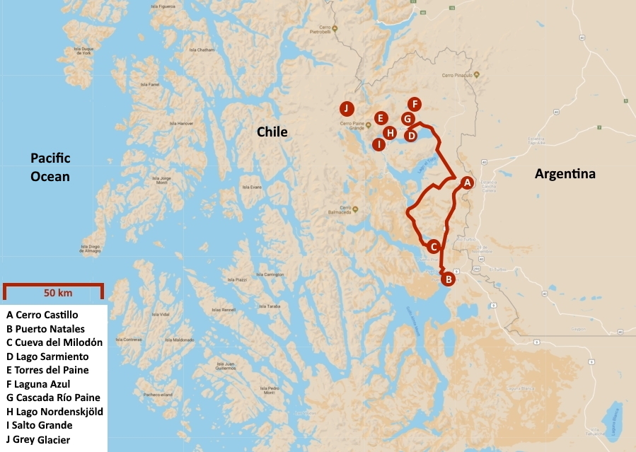
Tuesday, November 7 | Cerro Castillo – Puerto Natales
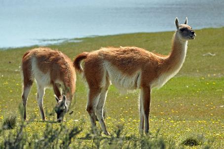
We have covered more than two hundred kilometres on RN40 since we left El Calafate this morning. It was a relatively dull route, over gently rolling terrain through the barren steppe. There wasn't much to experience along the way. Occasionally, a handful of rheas or a group of guanacos caught our attention.
This is slowly changing now. It's half past eleven when we turn right. Apparently, an unpaved road will be our last memory of Argentina for now. Not even fifteen minutes later, we stop at the border post of Río Don Guillermo. The border control when leaving Argentina is not extensive. Signing a form on the bus, queueing up for a stamp in our passports. Barely half an hour later, we continue. On a paved road, no less. Chile immediately makes a good impression.
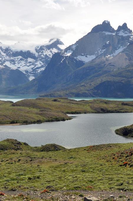
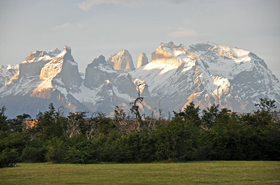
Cordillera del Paine
Ten minutes later, the Chilean border post of Cerro Castillo comes into view. A customs officer immediately approaches us with a leashed dog. Things get a bit more serious here, and we'll have to readjust our somewhat lighthearted view of border controls.
There are no issues at the border crossing – except for two confiscated apples
There are no issues at the border crossing, except for two confiscated apples. While the sniffer dog does its job on the bus, our hand luggage goes through the X-ray inspection in the office. No problems arise, and we quickly receive the necessary stamps in our passports. We will have to keep our Tarjeta Unica Migratoria carefully, as we will need to surrender it when leaving Chile.
Beyond the border post of Cerro Castillo
Meanwhile, our new guide Lorenzo has joined us. He immediately reveals himself as a bird enthusiast, with a camera slung across his chest serving as a constant reminder. Our luggage smoothly transitions from our Mercedes-Benz Marco Polo to a Mercedes-Benz Mascarello.
Nothing stands in the way of our exploration of sunny Chile now, except for lunch because we haven't eaten yet. El Ovejero, the Shepherd, a modest establishment, has it all – a souvenir shop, clothing store, supermarket, cafeteria, snack bar, and two red-hot stoves. We settle in for a quick meal.
This weather is not normal, complains Lorenzo as we continue our journey over an excellent concrete road just before two o'clock. While the temperature should be between 16 and 17 °C (61 and 63 °F), it's currently 19 °C (66 °F). Instead of wind and clouds, the sun dominates the blue sky. To add to our bad luck, it rained for three full days last week, turning the landscape marvellously green.
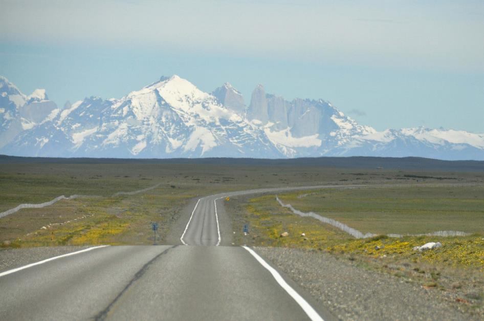
Along the excellent Route 9, chauffeur Gustavo takes us due south. A beautifully green valley surrounds us, with blooming yellow flower fields and a wall of white snow peaks on our right. This prompts a brief photo stop at Torres Magellan.
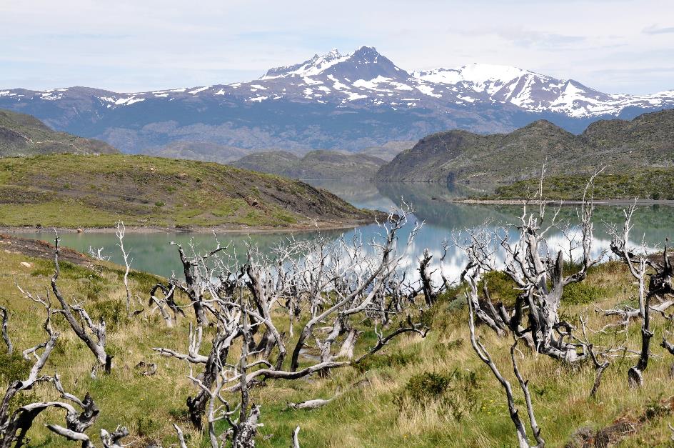
Many trees have succumbed, with most dying a natural death, says Lorenzo. Although the process is often accelerated by parasites. In the past, forests were sometimes burned to create more space for sheep farming, which has always been crucial in this region. Once again, it's mainly the false beeches that dominate the landscape. We're already familiar with the deciduous lenga and ñire from Tierra del Fuego, but the evergreen coihue is new to us. Also one of the parasites is familiar – Darwin fungus, also known as Indian bread.
The explicit intention was to colonize the area and raise sheep
Initially, scientists and explorers were the main ones interested in this remote region. It wasn't until 1893 that Hermann Eberhard settled at the mouth of the Río Natales. Along with Stubenrauch and Kark, Lorenzo considers him one of the three actual founders of the city. In 1911, Puerto Natales was formally established. The explicit intention was to colonize the area and raise sheep.
Today, the town has over 18,000 inhabitants. While sheep are still present, tourism now takes the lead. When the season arrives, the population will explode to three or even four times its regular size.
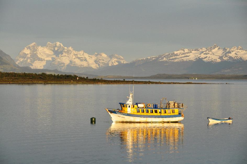
Puerto Natales – Seno Última Esperanza
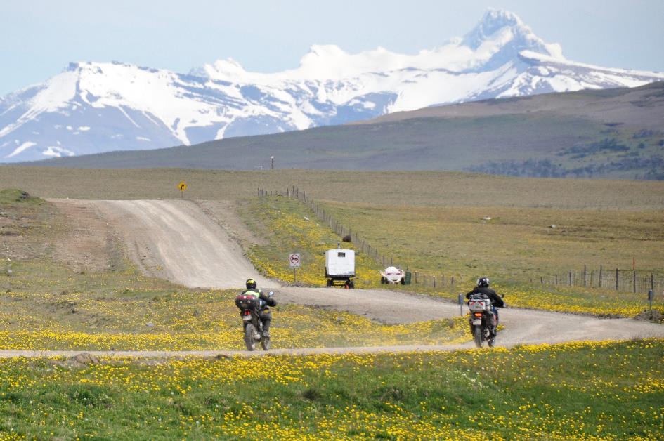
Meanwhile, the Seno Última Esperanza has made its appearance, the Fjord of the Last Hope. Strictly speaking, this is seawater. However, the open sea is located quite a distance to the west, hidden behind a tangle of inlets and fjords. In a straight line, it's about one hundred and fifty kilometres. You can't really call this water truly salty, especially since all the water flowing down from the mountains around Torres del Paine passes through here.
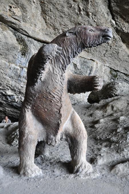
Shortly thereafter, we roll into Puerto Natales. A strange statue greets us at the first roundabout – it looks like a polar bear on its hind legs but with a long tail. This is a mylodon, Lorenzo explains, a prehistoric giant sloth. We will get to know more about it tomorrow.
Puerto Natales – Monument for the Wind |
|
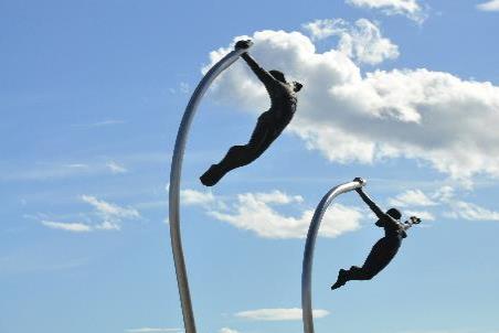
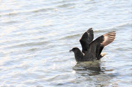
Skua |
A bit further, Lorenzo points out a monument that pays tribute to... the wind. To us, it looks more like two pole vaulters in full action.
Just after half past two, we check into the hotel. A magnificent postcard view of the fjord awaits us there. Boats gently bob on the sparkling water, sun-drenched snowy mountains dominate the distant shore.
Puerto Natales – Seno Última Esperanza
But there are still a few practical matters to attend to. Foraging for tomorrow's picnic, for example. Or acquiring Chilean pesos. In an exchange office on Hermann Eberhard, we get 720 pesos for one euro.
Wednesday, November 8 | Torres del Paine NP
Hermann Eberhard was in for a surprise in 1895 when he found bones and a piece of skin in a cave on Cerro Benítez. He couldn't immediately put a name to it. It was Otto Nordenskjöld who eventually identified the peculiar creature. He recognized the skeleton – a similar one had already been discovered in Argentina before. It turned out to be a mylodon.
An idyllic place, except that it was frequently subject to volcanic activity
A mylodon? We've never heard of such an animal. It was a distant ancestor of the sloth, Lorenzo explains as Gustavo heads north on Ruta 9. Actually, it was a ground sloth, as the animal walked on all fours on the ground.
It must have been a colossal beast, two meters long from head to tail, weighing a ton. It belonged to what we now call megafauna, a set of unusually large animal species that went extinct about ten thousand years ago.
Why that happened is still a matter of speculation. Some attribute the extinction to the climate change that occurred after the end of the last ice age. Others point a finger at modern humans who appeared on the scene and efficiently hunted these animals. It's likely a combination of these factors.
The discovery was reason enough to subject the cave to a thorough investigation. With success, as they found traces of other extinct animals. The sabre-toothed tiger, for example. Or the hippidion and the macrauchenia – creatures that we can't imagine at all but turn out to be distant ancestors of the horse and the llama. And prehistoric humans must have stayed in the cave as well.
About twelve thousand years ago, our mylodon must have met its end in that cave. Impressions of human teeth on the bones seem to suggest that people killed it. But that's not true, says Lorenzo, because there are also impressions of the teeth of a sabre-toothed tiger found. It's more likely that the sabre-toothed tiger did the killing, and people enjoyed the remains of the carcass afterward.
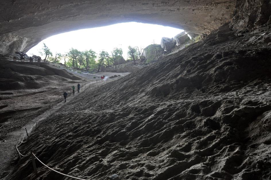
Cueva del Milodόn
Yet the sabre-toothed tiger is actually a painful failure of natural evolution, according to Lorenzo. Those large, sickle-shaped teeth on the outside of its mouth might have looked impressive. They could grow up to thirty centimetres long. However, they were quite brittle and easily broke. This could happen even with a hard contact with the bone of prey. Many fossils with broken teeth have been found. And what does a hunter do without teeth? Starve to death.
And what does a hunter do without teeth? Starve to death
Nowadays, Cueva del Milodόn, the cave where all this took place, is a tourist attraction about 25 km north of Puerto Natales. Today, it will be our first destination. But it's mainly Torres del Paine that we're looking forward to. It is said to be one of the most beautiful national parks, not only in Chile but in all of South America. All types of landscapes of Patagonia are present there.
The weather seems to be cooperating. There are hardly any clouds in the sky, and temperatures are expected to be around 17 to 18 °C (63 to 64 °F).
An unpaved road takes us to the foot of Cerro Benítez. There, we climb to Cueva Grande. Large is indeed an appropriate term for this cave, immensely large even – 200 m deep, 80 m wide, 30 m high. At the entrance, the most famous inhabitant of the cave greets us. It's a somewhat kitschy statue of the mylodon. Here too, it stands on its hind legs, perhaps to make a more impressive impression, as normally, it kept its feet on the ground.
In the past, the glaciers from the Andes reached this place. When they began to melt twenty thousand years ago, a lake formed in this valley. That water must have found a weak spot in the rock of Cerro Benítez. Little by little, the cave was carved out by the interplay of wind and water.
The mylodon belonged to what we now call megafauna, a set of unusually large animal species that went extinct about ten thousand years ago
Mylodon |
|
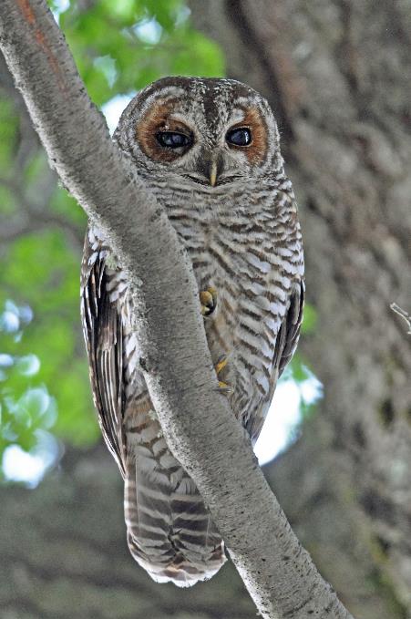
Rufous-legged owl |
Various stone tools have been found from the prehistoric people who inhabited the cave at that time – arrowheads, knives, scrapers, etc. From their cave, they must have looked out over an open landscape with many meadows and forests. And with a lot of water, as the fjord likely extended to the foot of the mountain since the sea level was significantly higher. An idyllic place, except that it was frequently subject to volcanic activity.
Undoubtedly, they also gazed down on the high rock that is now called the Silla del Diablo, the Devil's Chair. The devil would supposedly sit there to keep an eye on the surroundings. Although prehistoric humans probably gave it a different name.
A shy rufous-legged owl sits motionless in the twilight under the foliage of a tree. Insects, birds, and even small mammals are on its menu. According to Lorenzo, it's not a bird you see often; at first, he even thought it was a burrowing owl. The beautiful bird is not yet considered an endangered species, but deforestation by humans does not make life easier for it.
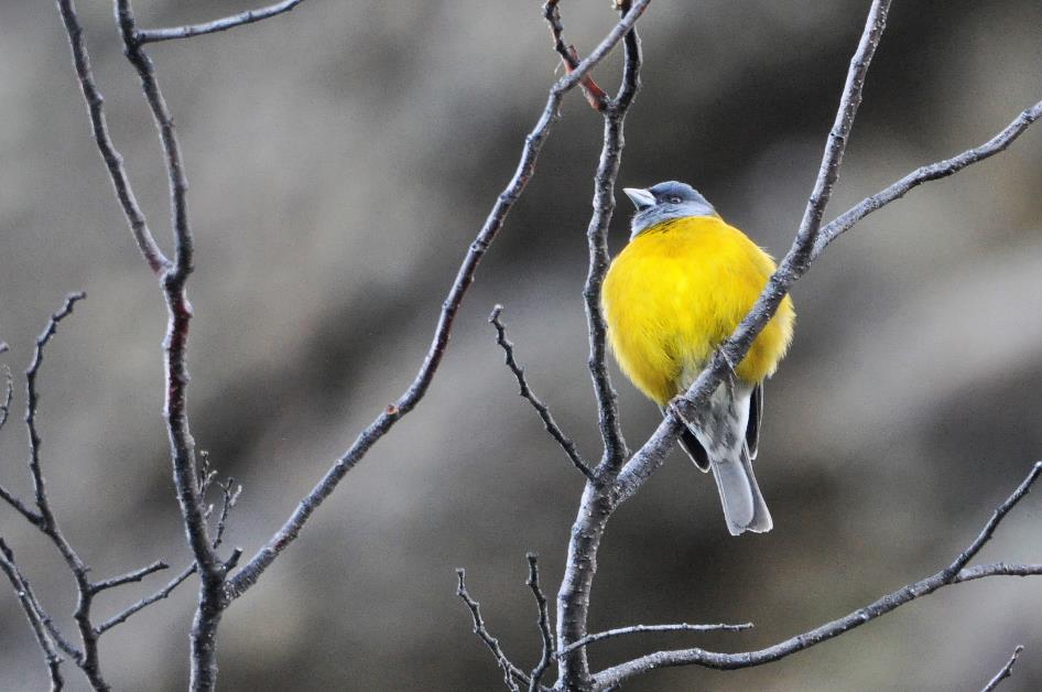
The Patagonian yellow finch
The Patagonian yellow finch is less bothered by that. He sits on a bare branch with a bright yellow plumage that you can't overlook. His meals are rather modest – seeds, insects, spiders.
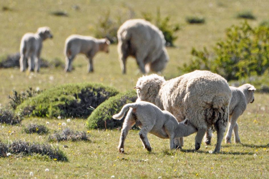
Merino sheep
Just after nine, we continue our journey to Torres del Paine. The unpaved Y-290 takes us through a rolling green landscape full of bushes and shrubs, sprinkled with yellow flowers and surrounded on all sides by snow-capped mountains.
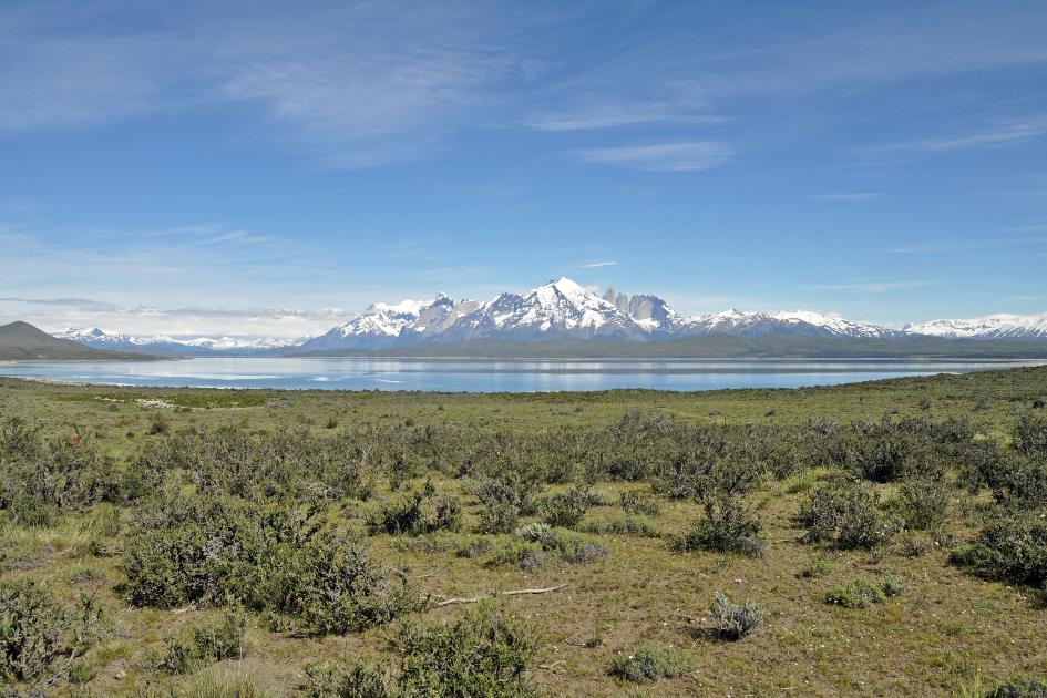
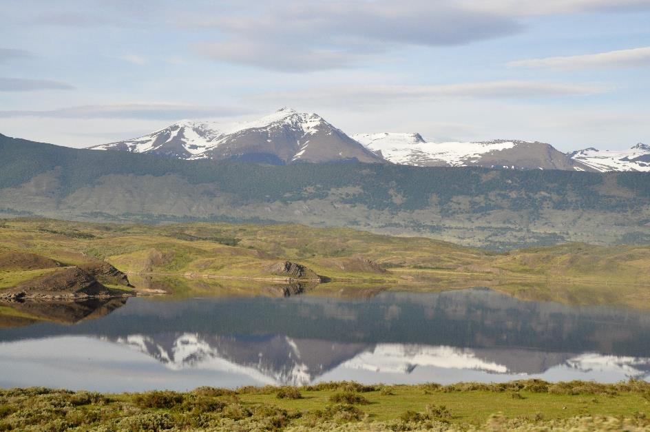
Mirador Lago Sarmiento – Cordillera del Paine
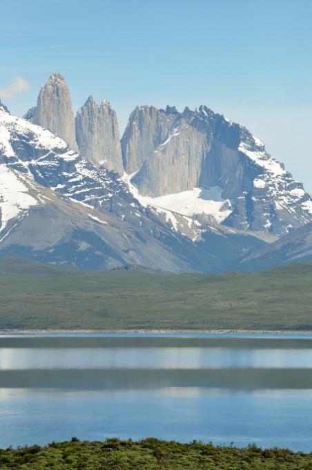
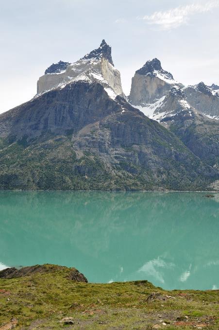
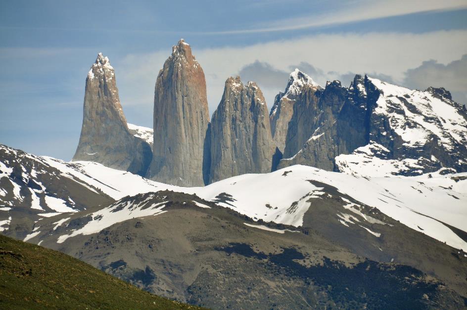
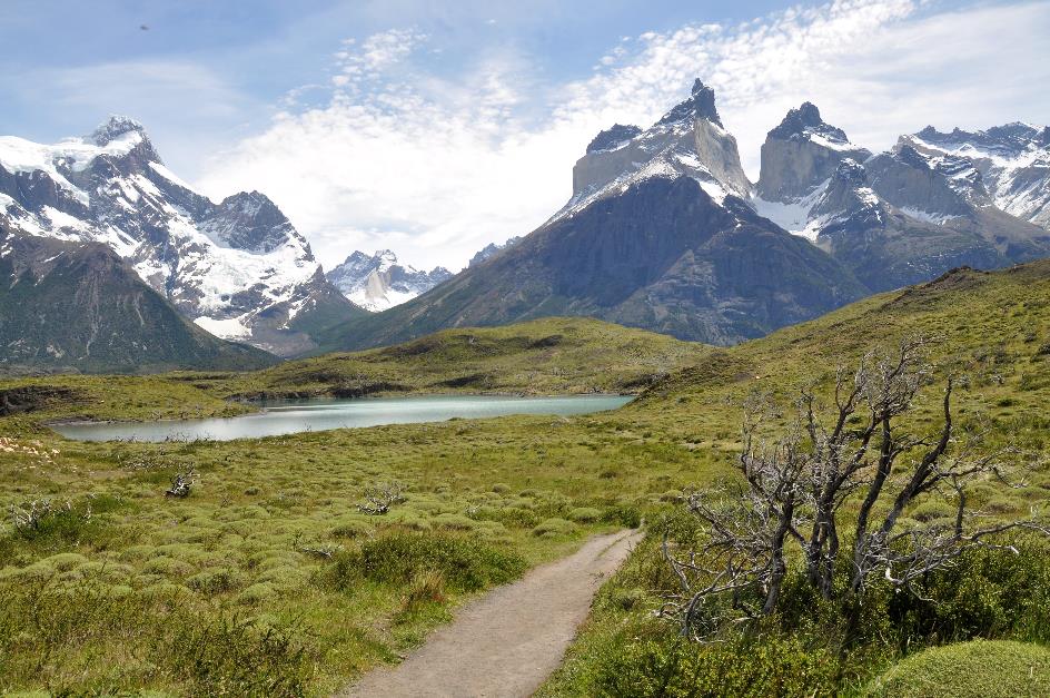
A half-hour later, Lago Porteño comes into view. Finally, there they are – the first peaks of the Cordillera del Paine, the central massif of the park. Still in the distant background, but clearly visible against the sky-blue sky.
It was the Scottish writer Lady Florence Dixie who pulled Torres del Paine out of anonymity in 1880. The Needles of Cleopatra, that's what she called the three famous peaks in her travelogue Across Patagonia – not without a slight penchant for sensation.
In 1959, the Chilean government declared the area a national park. However, it wasn't until 1970 that it received its current name, Parque Nacional Torres del Paine. Torres refers to the three peaks that rise as towers above the mountain range, and Paine means blue in the language of the Tehuelche – an allusion to the delightful reflections of the peaks in the blue water of the many lakes.
Moreover, the granite from which those towers are built formed twelve to thirteen million years ago, Lorenzo explains. Hot magma then welled up through cracks in the Earth's crust. The upward pressure was so great that the upper layer was pushed upward. An underground domed space formed, where the magma gradually solidified into a form of granite. Scientists call this a classic case of magmatic intrusion.
But that's only half of the story. For millions of years, this entire area has been slowly but steadily pushed upward. Plate tectonics are behind this, as we learned in school. Little by little, the plate on which the Pacific Ocean rests slides under the South American continental plate and steadily pushes it upward. That's how the Andes Mountains were formed.
Give a glacier enough time, and it carves out a deep, U-shaped channel
Over time, glaciers formed there. Give a glacier enough time, and it carves out a deep, U-shaped trough. No rock is resistant to this process, not even granite. When this abrasion occurs on either side of a block of granite, only a sharp ridge remains in between – geologists call it an arête. Gradually, the surrounding layers disappeared, leaving only the granite peaks of the Torres, Lorenzo concludes his geological excursion.
Mirador Lago Sarmiento – Cordillera del Paine
In 1978, UNESCO recognized this area as a biosphere reserve, providing special protection to its ecosystems. The fact that the park is currently doing reasonably well can be considered a small miracle. Before its recognition, it was overgrazed by cattle and especially sheep, the fauna was overhunted, and trees were felled in large numbers.
As if that wasn't enough, several massive forest fires occurred
As if that wasn't enough, several massive forest fires occurred. It began with the burning cigarette of a Japanese tourist in 1985. In 2005, a Czech backpacker accidentally knocked over a stove he was using against all rules. And in 2011, an Israeli backpacker thought it necessary to burn used toilet paper.
Each time, around fifteen thousand hectares (37,000 acres) of natural area went up in flames, and the park was closed for a while. An environmental disaster, but also a commercial catastrophe. The local economy relies entirely on tourism, and here it has only one asset – the natural beauty of Torres del Paine.
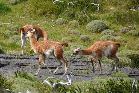
In the 19th century, it was common practice to hunt guanacos here. Both the meat and the skin were sought after. With the establishment of the park, this practice came to an end. The guanaco population has rebounded, and you can often encounter herds of ten to thirty guanacos now.
The situation has also improved for the pumas
The situation has also improved for the pumas. Sheep farmers had decimated their numbers, but nowadays, several dozen roam the park. In 2017, more pumas were seen than ever before. We would have liked to see one as well – from a respectful distance, of course. However, Lorenzo estimates our chances to be quite low.
Torres del Paine |
|
Ruta 9 |
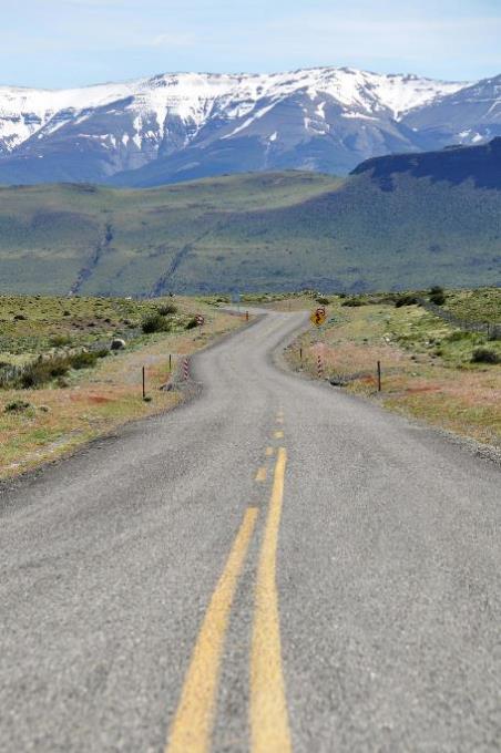
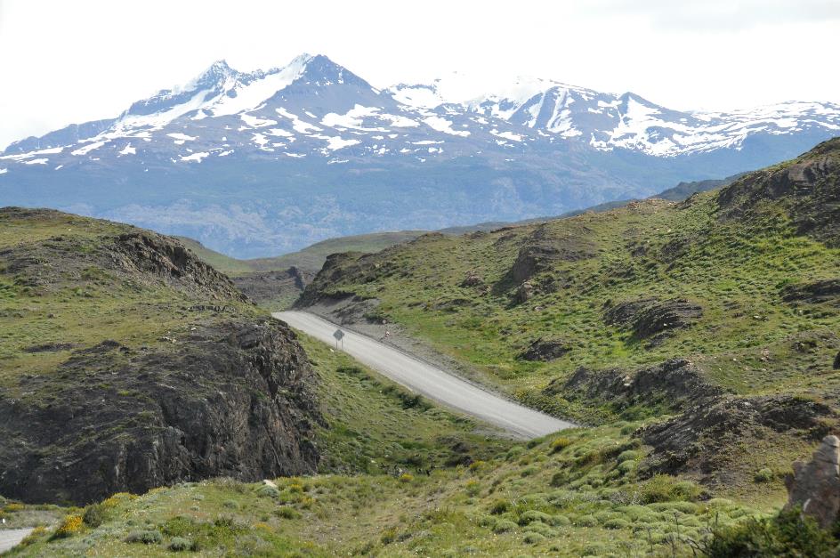
Shortly after ten, we leave the unpaved trail behind us. Along Ruta 9, we now head north. The strip of asphalt road that stretches out before us is almost ten kilometres long and perfectly straight.
On the left, the elongated Lago del Toro lies fairly calm. But it's not always like that, especially when a strong wind from the west rushes over the water surface parallel to the length axis. It covers a distance of thirty kilometres, more than enough for the wind to whip up waves that can be four meters high. It's as if the lake is as angry as a raging bull. It owes its name, Bull's Lake, to this phenomenon.
Vehicles also contend with these strong west winds. Conduzca Con Precaución – Vientos Laterales reads a sign along the road, Drive carefully – Side winds.
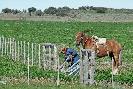
A gaucho inspects the fencing of his pasture. These horseback cattle herders are somewhat the South American equivalent of North American cowboys. Originally, you could only encounter them in the pampas of Argentina, Paraguay, and Uruguay.
They are called huaso's in Chile. Various hypotheses circulate about the origin of that word. Lorenzo maintains that it is derived from wackcha, which means a child without a father in the language of the Quechua. This indicated that these men were free and unbound but also detached from the community, living on the fringes of society. Essentially, it was a derogatory term.
The gaucho on horseback became the hero of rugged life in nature. Thus, the derogatory term evolved into a somewhat heroic concept
Since the end of the 19th century, the concept has been romanticized. The gaucho on horseback became the hero of rugged life in nature. Thus, the derogatory term evolved into a somewhat heroic concept, although it is still used in a disparaging sense.
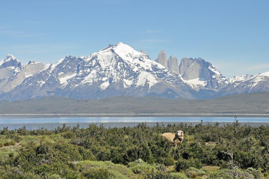
On the right, the Río de las Chinas winds lustfully through the valley, and sheep graze peacefully on the slope. Gustavo now leaves Ruta 9. A gray gravel path takes us to the shore of Lago Sarmiento.
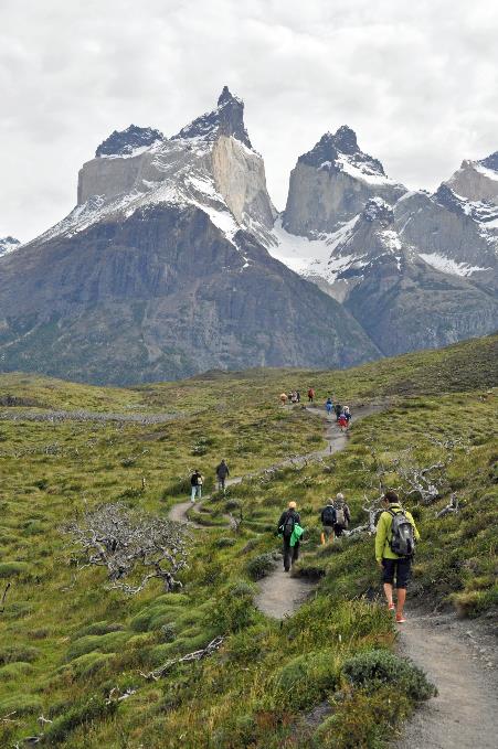
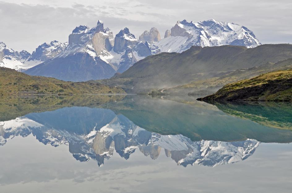
Slowly but surely, the three granite towers of the Cordillera del Paine come into view from behind the mountain range. We couldn't imagine better conditions to observe them. Lorenzo names them from left to right – La Máscara, La Hoja, and La Espada, or the Mask, the Blade, and the Sword. Although the mask is still somewhat hidden behind the mountains.
There is not the slightest haze in the air, not the slightest cloud around the colossal towers. They stand sharply against the steel-blue sky. In the foreground, we see the smooth water surface of Lago Sarmiento and some sheep grazing in the grass.
The towers vary in height from 1,850 meters to 2,050 meters. We already know their history of formation – hot magma welling up through cracks, solidifying into underground dome-shaped structures. A completely different story would have unfolded if that magma had managed to reach the surface, Lorenzo suggests. Because then, you get a real volcano. We will only get to know that in a few days.
Gaucho |
|
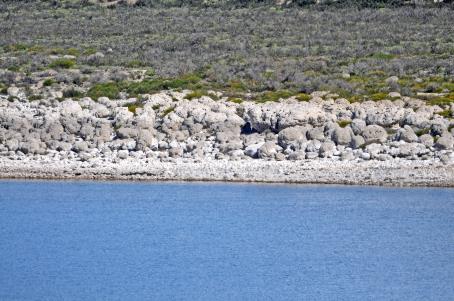
Lago Sarmiento – Thrombolites |
Further on lies Hotel Tierra Patagonia. It's an exclusive place where you can enjoy this view day and night. If you want to stay overnight, you should book at least three nights. For two people, that will cost you 5,800 dollar. But they are not unwilling to grant a restroom break to those with less means if they request it.
White-grey calcium deposits on the lake's shore immediately catch our attention as we settle at Mirador Lago Sarmiento. Lorenzo explains that these are thrombolites, limestone structures built by microscopic organisms. In that regard, they are not much different from coral reefs built by coral polyps in the sea.
The presence of thrombolites here is due to Lago Sarmiento having no rivers that drain water. This creates a strongly alkaline environment with many salts in the water and a pH of 9. For cyanobacteria, this is heaven on earth because they have no natural enemies like snails to contend with. Snails simply cannot survive in this water.
Thus, cyanobacteria work undisturbed here. They integrate minuscule sediment particles into their structures. The calcium carbonate they need for this appears as a by-product of their photosynthesis. This process has been ongoing for at least ten thousand years on the lake's shore.
But there's more. Oxygen is also a by-product of this photosynthesis. Cyanobacteria are considered among the oldest living organisms on Earth. They were the ones that started adding oxygen to the Earth's atmosphere three and a half billion years ago, paving the way for the emergence of higher life forms.
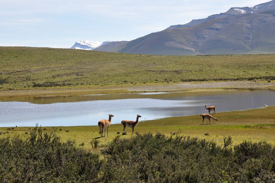
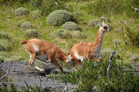
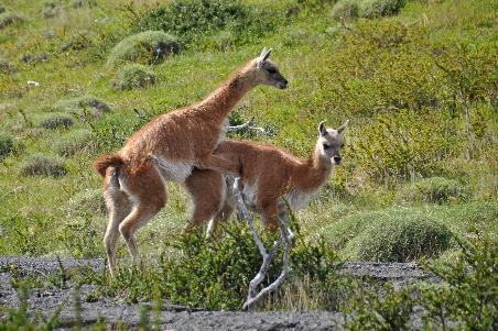
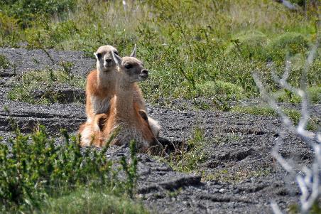
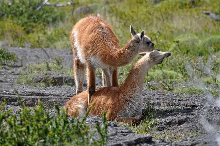
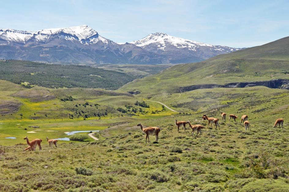
Guanacos
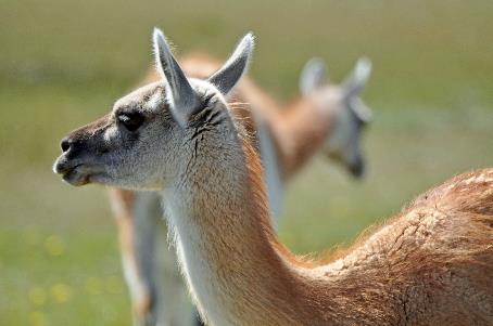
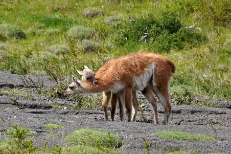
A little further on there are some guanacos grazing. It's a harem, where an alpha male takes care of many females. However, it's difficult to distinguish them because males and females hardly differ from each other. They don't have horns or antlers, at least.
They can run exceptionally well, reaching speeds of up to 56 km/h, even on steep and rocky terrain. They can also jump quite decently, up to 1.20 meters high. If they manage to avoid pumas, they can expect an average lifespan of about 25 years.
Guanacos |
|
|
If a female is pregnant, it takes eleven and a half months before a chulengo is born, a guanaco calf. Nature grants the mother a month of rest, but then she promptly becomes pregnant again.
For males without a harem, it's a bummer, of course. Displaced old ones form senior groups. Cocky young males wait in bachelor groups in the hope of eventually becoming sexually active.
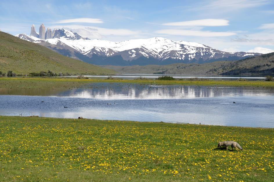
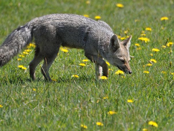
Torres del Paine, Lago Azul, Andean fox
The gravel track now winds steeply up and down the little hills through the valley of the Río de las Chinas. Occasionally, a small lake appears. Then the azure Laguna Azul comes into view from the window, one of the many lakes and lagoons at the foot of the Cordillera del Paine. Gustavo can't drive any further; last week's rains have transformed the dirt track into a mud puddle.
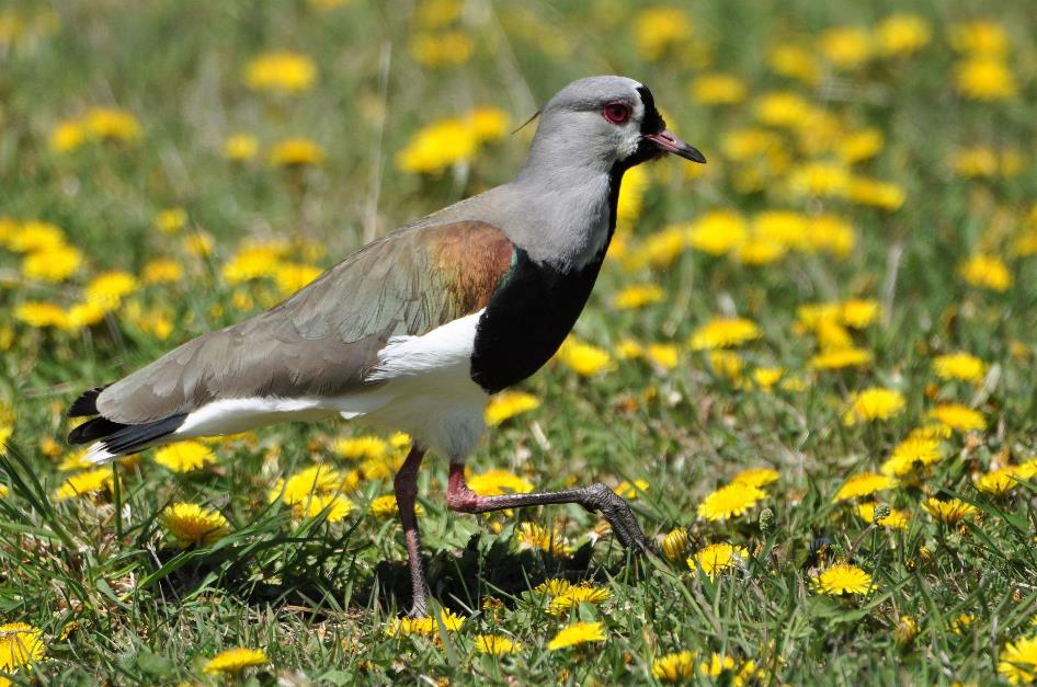
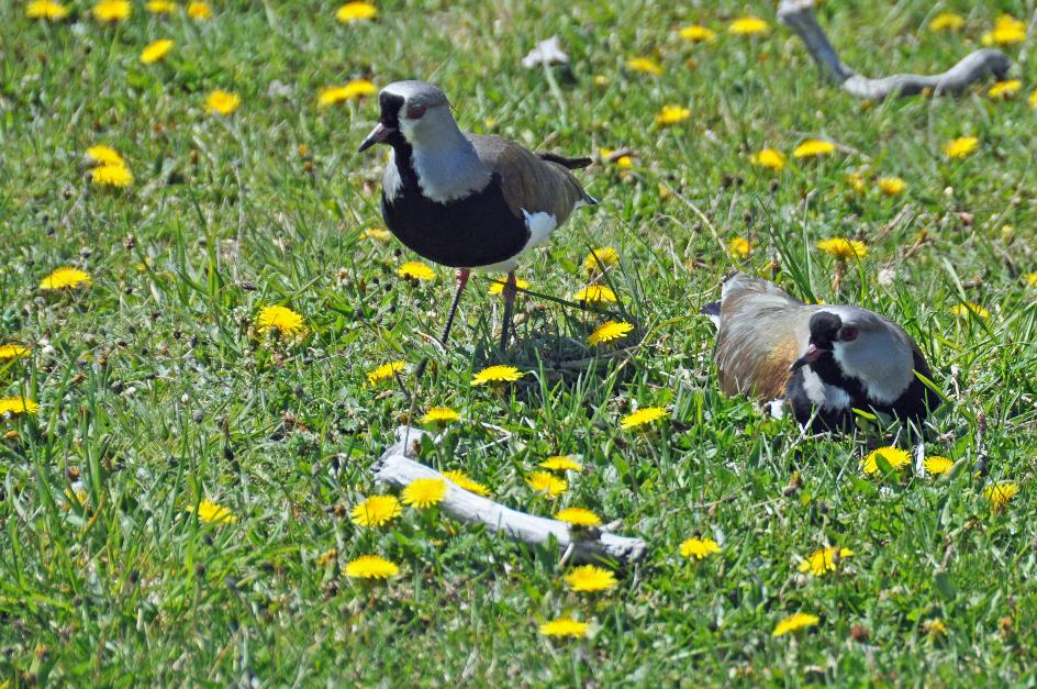
Chilean lapwing
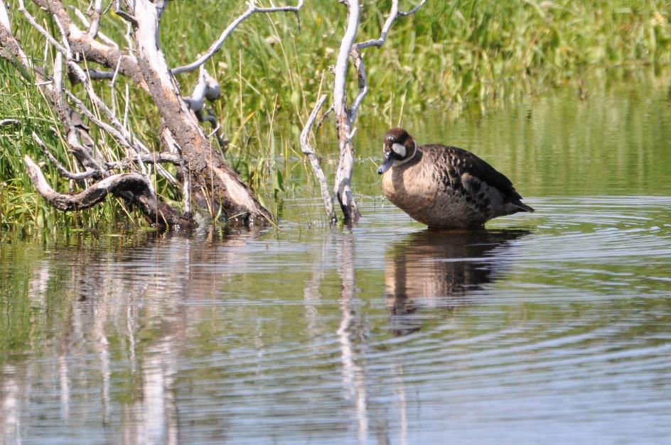
Fortunately, though. This way, we can take a good walk along the lagoon. The breathtaking scenery simply demands it. Ducks glide undisturbed in all directions over the water. Two young foxes stroll along the shore, eagerly sniffing among the yellow dandelions. The three towers rise majestically above the virgin white mountain ridge, flawlessly reflected in the ripple-free water. And above it all stretches the heavenly blue, almost cloudless sky.
Andean fox |
|
|
In the low grass, a pair of Chilean lapwings are nesting. Camouflaging the nest or providing any form of protection isn't in their job description. The female sits patiently on her eggs with a hint of unease in her eyes.
Camouflaging the nest or providing any form of protection isn't in their job description
The male nervously tiptoes around. He frequently moves his head vigorously up and down, as if he wants to convey that we should leave. His bronze shoulders sparkle in the sun during these movements. All this activity around the nest is getting on his nerves. Just a while ago, he had to chase away an audacious fox.
Torres del Paine
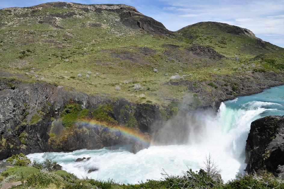
Twenty minutes later, we reach the bank of Río Paine, the river that flows from north to south through the park, connecting several lakes. Once again, Lorenzo has a stunning spectacle in store for us, the Cascada Río Paine.
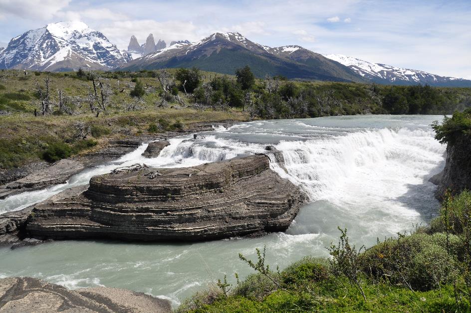
Cascada Río Paine
A waterfall, yes, but what a magnificent setting it is. Over a width of fifty meters, the water plunges on either side of a giant rock formation about ten meters down, with, in the background, those three imposing towers and the dazzling snow-covered massif.
Even in this environment, lunchtime is inevitable. Just after two, Gustavo drops us off at the parking lot of the Ranger Station of Laguna Amarga. We won't get any information about the park there because the rangers are on strike. Quite rightly so, Lorenzo adds. The park receives over two hundred and fifty thousand visitors annually, but the revenues mostly go to the north of Chile. Meanwhile, the rangers' salaries are barely above the legal minimum.
Fortunately, visitors don't have to suffer from it. The rangers don't hinder us. Carefree, we have a picnic with a view of the Torres del Paine.
While Gustavo continues to penetrate further south into the park, Lorenzo wants to talk to us briefly about his homeland. With an area of 756,102 km², Chile ranks fourth in South America. Only a quarter of Argentina's size, but still larger than France. No country in the world looks so slender on the map – 350 km at its widest, 64 km at its narrowest.
This country has seventeen million inhabitants. In principle, that's 22 people per square kilometre, but in practice, about 40 % live in the metropolitan area around the capital, Santiago de Chile.
As for the origin of the name Chile, various hypotheses circulate. But for Lorenzo, it is certain that the Mapuche people gave their country its name. In their language, chilli would mean where the land ends.
The blue of the Chilean flag represents the sky that is always blue – if you're a bit lucky
There is less ambiguity about the meaning of the colours of the Chilean flag. The white represents the Andes Mountains, the red symbolizes the blood shed during the struggle for independence, and the blue stands for the always blue sky – if you're a bit lucky. The white star on the blue background, finally, should encourage us on the path of progress and honour.
Lagunas Melizzas
A moderately steep climb takes us high above the valley of the Río Paine. The gravel road now gently undulates over hills ranging from two to three hundred meters high, while one small lagoon after another comes into view. Gustavo is busy navigating the curves. Then, on the left side, the enormous Lago Sarmiento makes its appearance again, shortly followed by Lago Nordenskjöld on our right. Rio Paine flows right through it, contributing to the lake's beautiful azure colour.
There's plenty of reason to take a leisurely look at all of this from Mirador Lago Nordenskjöld. In the distance to the left, we can spot Cerro Paine Grande, the highest peak in the park at 3,050 meters.
Mirador Lago Nordenskjöld… |
|
…with mata guanaco shrubs |
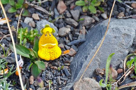
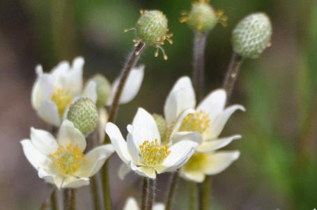
Nice, but this time it's not only the mountains across the lake that manage to charm us. Right before our feet, it's the tiny slipper flowers that capture our attention. In colourful groups of a dozen or more, they stand together among the low grass. They look like small, ochre-yellow gnomes about ten centimetres tall, holding a white-brown package in their hands, ready for delivery. It was Charles Darwin who first described the plant. That's why they also call it Darwin's slipper, due to its resemblance to a little slipper.
They look like small, ochre-yellow gnomes about ten centimetres tall, holding a white-brown package in their hands, ready for delivery
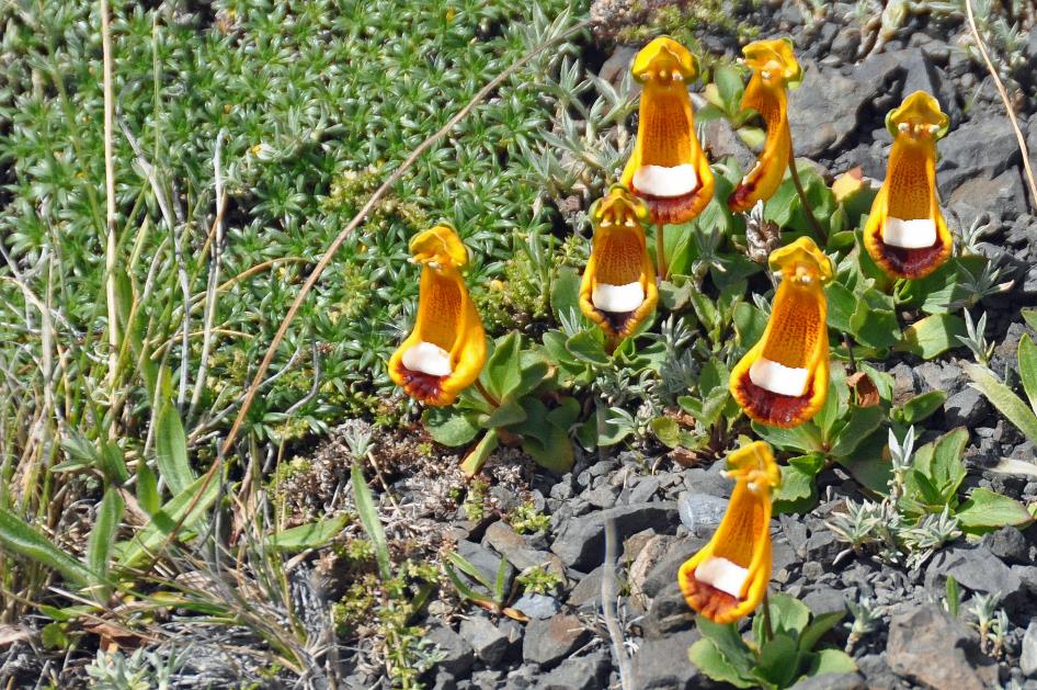
Slipper flowers
Slipper flower |
|
Mata guanaco |
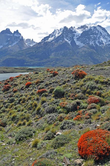
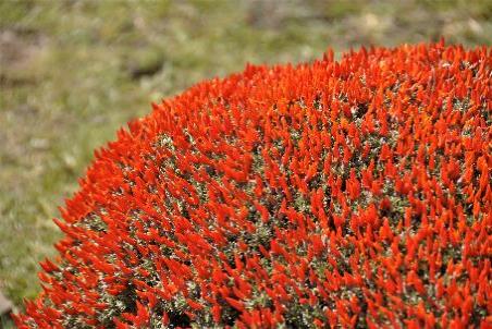
But the mata guanaco also manages to enchant us, although it's of a completely different nature. They are large, round shrubs with a diameter of a meter or more. It looks like scarlet broom, now that the plants are in bloom with flowers covering the entire bush like fiery tongues. And that is quite exceptional, according to Lorenzo, as they only bloom twice a year for a few weeks. Aren't we lucky.
Guanacos
Between the Lagunas Melizzas, we continue our journey, entering the area where eighteen thousand hectares (44,000 acres) went up in flames in 2011. Bare whitish-grey stumps of burned trees still remind us of that environmental disaster. Lorenzo has no explanation for why these burned trees are not black.
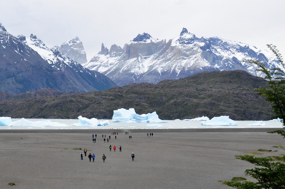
Swiftly heading south along the water of Lago Pehoé, the landscape gradually becomes less impressive. The clouds gradually taking over the sky doesn't even bother us. It's clear that we are leaving the park. Shortly before half past four, after crossing the Río Serrano, it becomes a reality.
We climb for a moment to Mirador Río Serrano just outside the park. Below, the Río Serrano meanders widely through the plain. Here and there, it has even overflowed its banks. It has had to handle a large flow, as it drains the entire Cordillera del Paine into Última Esperanza.
Twice a year, chinook salmon swim up this river to spawn. Currently, these are the lighter specimens weighing 12 to 15 kg, and only in January will the heavyweights arrive – 20 to 25 kg.
In the distance, Lorenzo points out our hotel in a sweeping hairpin bend of the river. We arrive just before five o'clock.
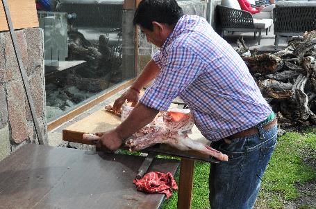
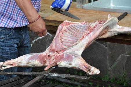
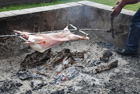
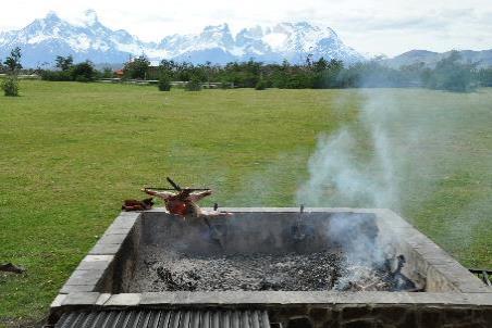
With meticulous care, the chef strings up a skinned lamb on a double iron cross to slowly roast it over an open-air fire
Cordero al palo – Stringing up the skinned lamb |
|
Seasoning |
Labour-intensive preparation |
|
Done |
A chef has just begun preparing a cordero al palo. Meticulously, he stretches a skinned lamb on a double iron cross. Placing it like a kind of flagpole above an open-air fire, he lets it slowly cook. For two hours, he will personally oversee the preparation. Regularly, he turns the lamb a bit, adjusts the angle of the pole, pours water over the meat, making sure the fat neatly drips over the meat. A preparation that requires a lot of dedication, but also a lot of time – considering that it involves just one ingredient of a meal. That's how the gauchos did it in the steppe.
Torres del Paine – Evening sun
Thursday, November 9 | Torres del Paine NP
Our streak of good luck seems to have no end. Generously, the morning sun spreads its warm glow over the Torres del Paine. It's a delightful awakening with that scenery in your backyard and a blue sky on the horizon.
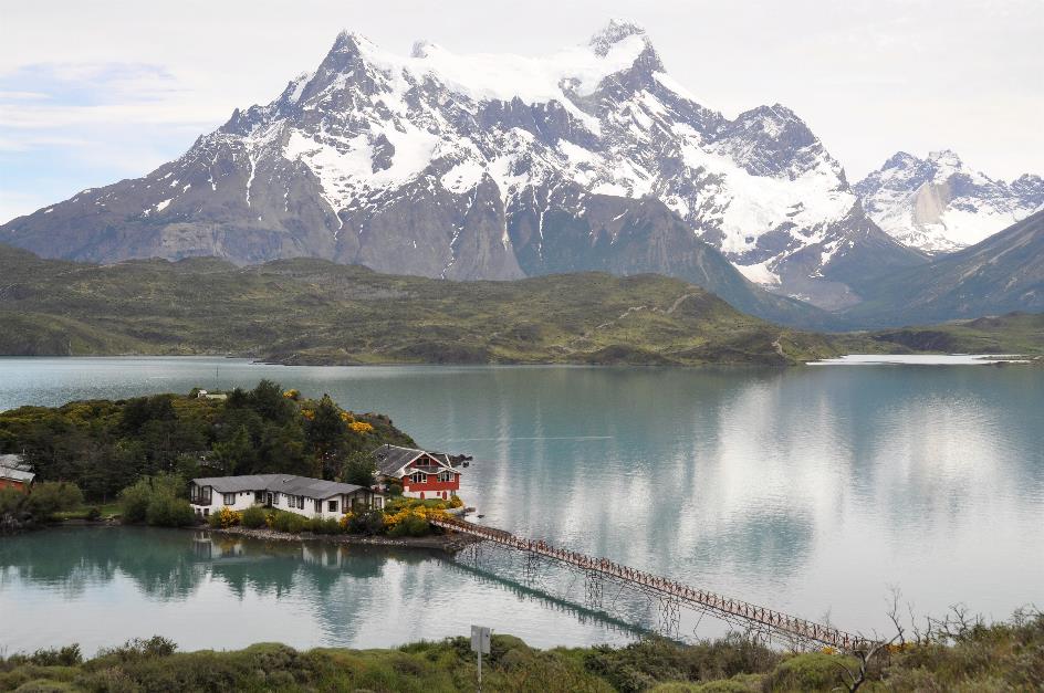
Barely have we set off, and the perfect shot presents itself. Almost over its entire width, the water of Lago del Toro lies perfectly still in the windless setting of Puente Weber. The glorious Cordillera del Paine reflects itself in it, with none of the three peaks missing in this scene – not only are the torres and the cerro shining prominently, but also the cuernos, which we will get to know more closely later.
Puente Weber – Cordillera del Paine, Lago del Toro
Not without difficulty, we tear ourselves away from the idyllic scene and continue our journey along the shores of Lago Pehoé. Quickly, Lorenzo hops into Parrilla Lago Pehoé to arrange lunch.
A little later, we strike gold again. From a height, we look down on the picturesque Isla Notro in Lago Pehoé. On the island, the yellow paramela adds its own colour accent to the scenery. The fragrant lathyrus or sweat pea also blooms lushly around us with its purple and white flowers. On the other side of the lake, the cerro and the cuernos rise above the water.
Lago Pehoé – Isla Notro
A pedestrian bridge connects the island to the shore because on that little island stands Hostería Pehoé. It has been there since 1949, predating the establishment of the national park. This immediately explains its presence in the heart of the park because, since then, no more hotels are allowed to be built.
They call themselves El secreto más oculto de Torres del Paine, the best-kept secret of Torres del Paine. In practice, the secrecy seems to be a bit exaggerated. Virtually no one can enter the park without catching a glimpse of the best-kept secret hotel and taking a photograph of it.
Lorenzo has emphasized the importance of bringing something warm with us – you never know with Patagonia
Gradually, our stroke of luck seems to be coming to an end. Clouds are rolling in, but the Cordillera continues to bask in the generous sun. There is no wind, yet Lorenzo has emphasized the importance of bringing something warm with us – you never know with Patagonia.
Salto Grande
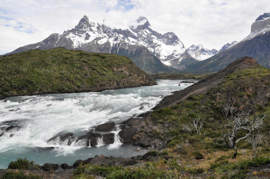
A short walk brings us to Salto Grande. With a lot of noise, the azure-blue water of the Río Paine plunges down a height of 65 meters. Second after second, a hundred cubic meters of water flow through a narrow gorge here. Nevertheless, this turbulent water will have calmed down enough about ten kilometres downstream to create the tranquil mirrored surface at Puente Weber.
To the Mirador Los Cuernos
We continue our hike to the Mirador Los Cuernos. It's a four-kilometre journey through an overwhelming landscape. They describe the difficulty level of the hike as moderate, mainly because it can be windy. However, there's currently no wind. So, it should be a piece of cake.
Wildflowers abound along the path, and many of them are in bloom
Sweet peas |
|
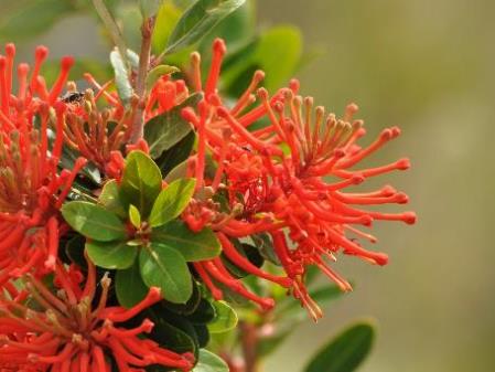
Chilean firebush |
Constantly, the sun pierces through the light clouds. Wildflowers abound along the path, and many of them are in bloom – the scarlet Chilean firebushes, the purple and white sweet peas, the yellow calafate bushes, the pale yellow native anemones on their long stems, ... Unfortunately, there are also the numerous whitish-grey tree stumps that remind us of the fire, their dead branches almost like a lamentation raised to the sky.
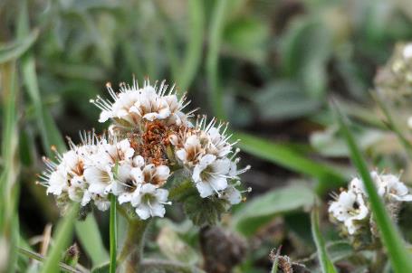
Hierba de la cuncuna or caterpillar grass |
|
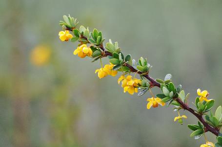
Calafate |
A peculiar addition to the mix is the phacelia. With its white flowers in clusters on an outspread stem and stamens that protrude far above, it resembles a hairy white caterpillar. That's why they call the plant hierba de la cuncuna – caterpillar grass.
|
|
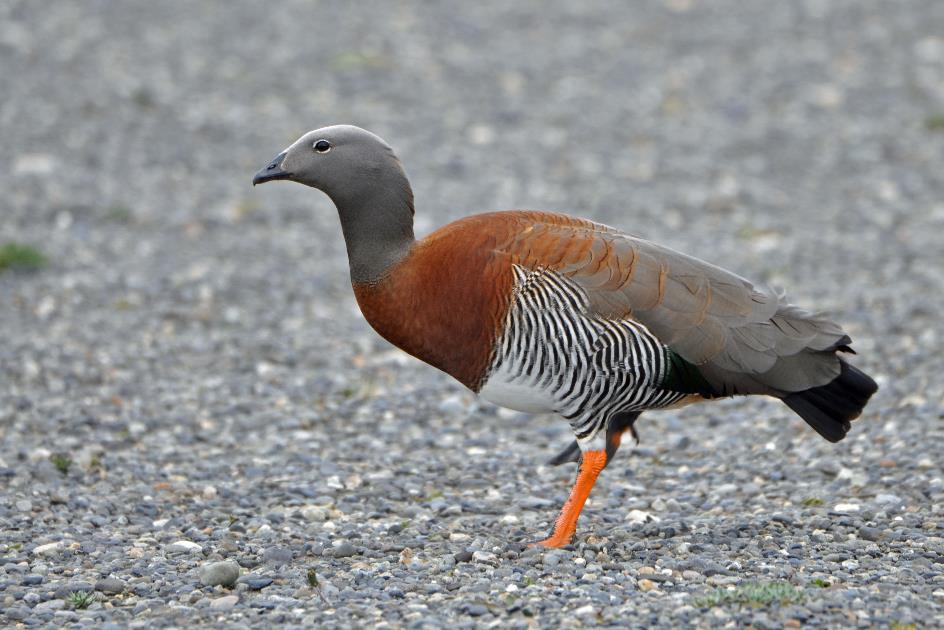
Upland goose (m) |
The presence of a rufous-collared sparrow is not disturbed by us; it no longer pays much attention to people. It sports a beautiful reddish-brown collar around its neck. This songbird prefers to perch calmly on a branch, but for its lunch, it’s forced to the ground, searching for seeds and worms.
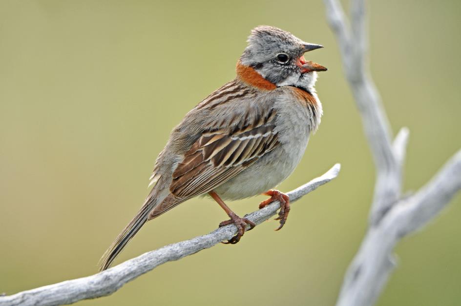
Rufous-collared sparrow
Even though all males sing the same song, there are minimal differences that reveal their origin. It's a kind of dialect, in a way. Chicks will mimic the dialect of their group from the very beginning. Females can use this to determine which population group the male belongs to. This likely contributes to the genetic diversity of the species.
Cerro Paine Grande (on the left), Lago Nordenskjöld, Los Cuernos (on the right)
But, of course, it's the cuernos that steal the show. We approach them closer and closer, while they tower higher and higher above us. When we finally reach Mirador Los Cuernos on the shore of Lago Nordenskjöld, we are still more than five kilometres away. But that doesn't diminish their grandeur. And on the left, the impressive Cerro Paine Grande adds to the scenery.
On the way to Mirador Los Cuernos |
|
|
Sediment on the top of a granite peak? That's the world turned upside down. Literally
Mirador Los Cuernos |
|
Sediment on the top of a granite peak |
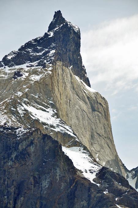
The cuernos are not the torres, Lorenzo emphasizes – horns are not towers. Immediately, we notice the dark sediment layer on top of the pale granite columns. The line marking the transition between sediment and granite is razor-sharp.
Sediment on the top of a granite peak? That's the world turned upside down. Literally. However, it is indeed sediment that is up there, not basalt or the like. This is evident from the ammonites found there. At some point, that sediment must have been part of a seabed. The fact that this seabed is now at an elevation of 2,600 meters is, of course, related to the upward movement of the Andes.
Suddenly, a dull, rumbling sound in the distance grabs our attention. An avalanche, Lorenzo smiles. Undisturbed, he continues his geological explanation. The fact that erosion still hasn't managed to get rid of that sediment layer is another story. The hot magma that welled up back then didn't solidify immediately. It heated the overlying sediment layer so much that it was essentially baked – with ammonites and all. The sediment turned rocky and was much more resistant to erosion.
The male is in the mood. But the female is not. Several times, she rebuffs him
|
|
|
|
|
|
|
|
|
Overwhelmed by the magnificent landscape and its history, we return to the bus. Along the path, a harem group of guanacos has appeared. The male is in the mood, that much is clear. But the female is not interested. Several times, she rebuffs him. Eventually, he succeeds. Contentedly, he goes about his business, his long ears pressed against his neck out of pure pleasure.
Salto Grande
Meanwhile, the sun has focused on Salto Grande. Its generous rays paint a magical rainbow in the mists above the waterfall. On the other side, a Fuegian steamer duck is sunning itself. It can weigh four to five kilograms. Once mature, it no longer has to fear predators. Fortunately, because it can't fly – its body is too heavy with those small wings.
Bronze-winged duck
Further on, in a lagoon, we spot a bronze-winged duck. The funny white spot under its eye makes it easily recognizable. It's also called a spectacled duck for that reason. It mainly feeds on plants but also enjoys insects and tadpoles.
A great meadowlark is perched on a pole, showing off its red chest. It's a male; the female is probably somewhere busy gathering food for the nest.
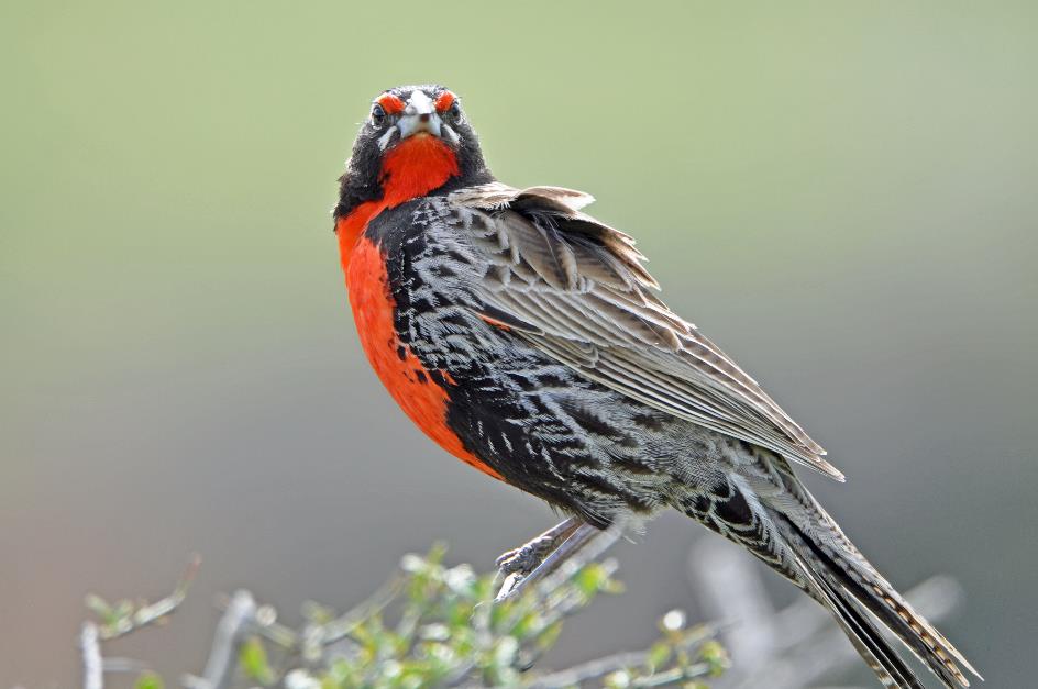
Long-tailed meadowlark (m)
We briefly stop at Parrilla Lago Pehoé for a lunch buffet. The atmosphere is notably smooth and friendly. Then we hit the road again.
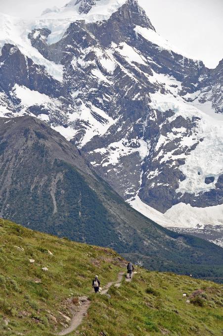
The state of the Grey Glacier is not so good, Lorenzo begins his story as we head upstream along the Río Grey in search of the glacier. For many years now, it has been shrinking at an alarming rate of around two hundred meters per year.
There are even two nunataks visible, he adds – as if that's the ultimate humiliation for a glacier that respects itself. A nunatak is the term used by the Inuit for a rock outcrop that is visible in a glacier or ice field.
At exactly three o'clock, Gustavo drops us off at the Ranger Station of Río Grey. The cafeteria has been in operation for just two weeks – a contemporary structure discreetly embedded in nature.
Now, we continue on foot. A suspension bridge takes us to the other side of the river. Through a forest of large, heavy beech trees, we descend to the river. Some trees have died, not due to fire or disease, but simply from old age, Lorenzo reassures us.
With every step we take, the temperature seems to drop
Terminal moraine of the Grey Glacier, Cordillera del Paine
Often, the eerie beard moss hangs from the branches. It's actually a symbiosis between a fungus and some algae. The fungus is responsible for growth, while the algae take care of collecting and storing water. The more of these lichens there are in the forest, the purer the air is.
At the edge of the forest, the path opens up to an immense pebble plain. This is the terminal moraine of the glacier. Immediately, we feel the cool wind brushing against our cheeks. Lorenzo had mentioned earlier that we might need an extra layer of clothing, and he turns out to be right. The sun no longer plays a role because it’s blocked by a dense, grey cloud mass.
In a very short time, it has become overcast and windy. That's how it goes in Patagonia. We knew that, but with all the beautiful weather of the past few days, we had somewhat lost sight of this scenario.
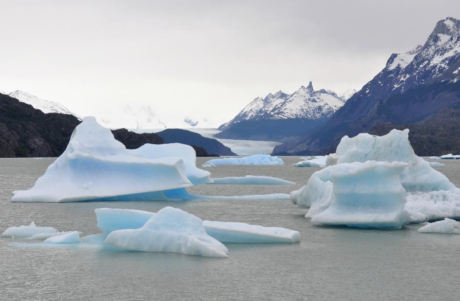
Lago Grey, Grey Glacier
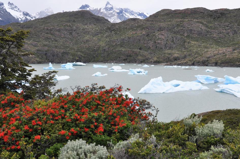
In the distance, dozens of blue-white icebergs float in the water. A natural dike of pebbles holds the glacier water of Lago Grey in check. Above that, the Cordillera del Paine towers in all its glory. The cuernos, the torres, and the cerro, all three are present. It looks promising, although there's still no sign of the glacier.
We walk through the pebbles towards the dike. With every step, the temperature seems to drop. On the meters-high dike, we survey the surroundings. A biting wind comes at us from between the icebergs. However, the glacier stubbornly hides behind the walls of the valley it has carved out.
The fact that so many icebergs have broken loose is mainly due to the heavy rains of last week. They aimlessly float in the six-hundred-meter-deep lake because they can't go anywhere. Río Grey is far from deep enough to carry these giants to Última Esperanza. Icebergs that tried against their better judgment to do so are stuck at the beginning of the river.
No matter how large some of these beautifully majestic icebergs may be – the largest is four to five times the length of the sailboat Lorenzo sailed here a few days ago, he says – an inglorious end is inevitable. Sun and rain will ensure that, without any mercy.
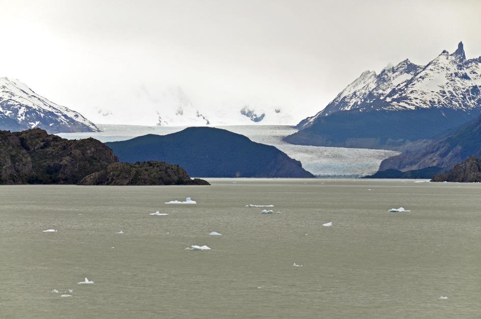
As we progress along the dike, the glacier gradually emerges from behind the hill. If we want to admire it in all its glory, we will have to climb to Mirador Lago Grey on an island directly opposite the glacier.
Cordillera del Paine, Lago Grey, Chilean firebush
A comfortable path leads us upwards. However, the view of the glacier turns out to be a bit disappointing. It is located fourteen kilometres away. That is even a little closer than the Upsala Glacier last week in Los Glaciares. But it's the clouds and mist that put a damper on our expectations. This glacier doesn't show its full self. Remembering Pablo's wise words, we should have known – it often snows up there.
This glacier doesn't show its full self
Grey Glacier
In the meantime, grey clouds have gathered above the Cordillera del Paine as well. Yet, it remains a fascinating sight – the dark blue, snow-covered peaks, the blue-white icebergs in the grey water, and the flaming scarlet firebushes in the foreground.
Ashy-headed goose
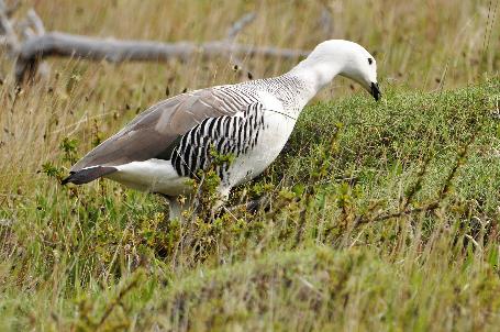
In the pebble plain, a pair of upland geese and a pair of ashy-headed geese are foraging. They do not interfere with each other, as they are distant relatives.
These ashy-headed geese are magnificent birds with their chestnut-brown necks and their white bellies adorned with a distinguished black stripe. They are closely related not only to the upland geese but also to the kelp geese. However, swimming is not their forte; they prefer to inhabit high-altitude, humid forest areas.
On the way back, it actually starts raining. So it's high time to head to other places. This will happen as early as tomorrow. Very early, to be precise.
Jaak Palmans
© 2024 | Version 2024-01-27 15:00
Continue reading in (6/7)